Abandoned 'slate' quarry, Abereiddi Bay, Pembrokes…
'Blue Lagoon' Abereiddi, Pembrokeshire
Outer Head and Middle Head - Worm's Head peninsula
Devil's Bridge - Worm's Head
Rhossili Bay - classic view
Benacre Cliffs - Westleton Formation
Collapsed pill box at Benacre Cliffs
Benacre Cliffs cross-bedded gravels 1
Benacre Cliffs cross-bedded gravels 2
Looking towards Southwold from Benacre Cliffs
Benacre Cliffs - Norwich Crag bioturbated clay wit…
Norwich Crag at Benacre cliffs
Benacre cliffs - Norwich Crag cross-bedded sands
Benacre cliffs: Norwich Crag cross-bedding detail
Benacre Silver Birch
Benacre Silver Birch (BW)
Benacre Broad breach channel to the North Sea
Benacre Broad and breach channel
Benacre Broad at low tide
Please avoid emptying your dog in Southwold
Look - but do not empty your dog
Southwold convergence
Southwold beach huts
Traeth Llyfn, Pembrokeshire
Lichen at Traeth Llyfn in the late afternoon sun
Traeth Llyfn rock ridges, Pembrokeshire
Laxford Bay, Sutherland
Achmelvich Bay north inlet, Sutherland
Porth Maenmelyn, Pembrokeshire, Wales
Loch Cùl Fraioch and the Torridonian mountains
Stoer cloudscape
Sunny Culkein
Suilven from Sìdhean Mòr
Stoer Head lighthouse
Old Man of Stoer
Old Man from Point of Stoer
Landscape with clouds
Sizewell across the marshes
Marsh Beach Sea
Balchladich Bay, Stoer peninsula, Sutherland
Storm beach at Aberbach, Pembrokeshire, Wales.
Rainbow over Brochel castle, Raasay, Scotland
Harwich Haven Pilot boat
Cosco Spain under the cranes
Loading containers
1/250 • f/9.0 • 28.0 mm • ISO 100 •
Canon EOS 350D DIGITAL
Location
See also...
Keywords
Authorizations, license
-
Visible by: Everyone -
All rights reserved
-
225 visits
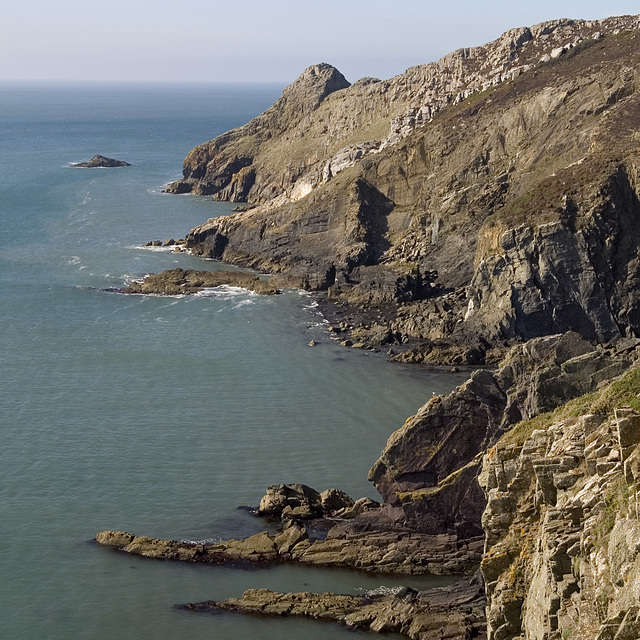
Pwlldawnau and Penbwchdy, Pembrokeshire


The little inlet of Pwlldawnau and the headland Penbwchdy, viewed from adjacent to the Pembrokeshire Coastal Path at National grid ref. SM 8808 3692 (a nice place for a sandwich).
The prominent pale rock horizon consists of sandstone and conglomerate at the base of the Ordovician age Ogof Hen Formation. This rests unconformably on the underlying shales of the Cambrian age Lingula Flags. The far headland of Penbwchdy is comprised of a microtonalite sill, an igneous intrusion. If you zoom in on the photo you can see near-vertical columnar cooling joints in the sill.
The prominent pale rock horizon consists of sandstone and conglomerate at the base of the Ordovician age Ogof Hen Formation. This rests unconformably on the underlying shales of the Cambrian age Lingula Flags. The far headland of Penbwchdy is comprised of a microtonalite sill, an igneous intrusion. If you zoom in on the photo you can see near-vertical columnar cooling joints in the sill.
(deleted account) has particularly liked this photo
- Keyboard shortcuts:
Jump to top
RSS feed- Latest comments - Subscribe to the comment feeds of this photo
- ipernity © 2007-2024
- Help & Contact
|
Club news
|
About ipernity
|
History |
ipernity Club & Prices |
Guide of good conduct
Donate | Group guidelines | Privacy policy | Terms of use | Statutes | In memoria -
Facebook
Twitter

Sign-in to write a comment.