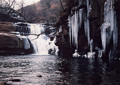
Yorkshire Dales
Kisdon Force,Swaledale
| |
|
|
Kisdon Force is a series of waterfalls on the River Swale in Swaledale, England. The falls are situated at grid reference NY898010 within the Yorkshire Dales National Park in the county of North Yorkshire, 500 metres downstream from the small hamlet of Keld.
Kisdon Force is one of several waterfalls on the Swale in the Keld area, the others being East Gill Force, Catrake Force and Wain Wath Force. All occur where the river cuts a gorge through the Carboniferous limestone between the hills of Kisdon and Rogan's Seat. The falls in this area are termed forces after the Norse word fors or foss, which means "waterfall". Both upper and lower Kisdon Force can be negotiated by canoeists, although a high degree of skill and experience is needed. The upper falls are rated Grade IV, while the lower falls are rated more difficult at Grade V.
The falls drop 10 metres (33 ft) over two cascades and are surrounded by Kisdon Force Woods, a Site of Special Scientific Interest covering an area of 38 hectares, which consists of mixed broad-leaved woodland with ash, wych elm and rowan trees dominating. In the springtime Primula vulgaris grows profusely in the area. The falls can be easily visited by a riverside path from Keld; however, care should be taken, as the stones around the falls are often wet and slippery. Visitor numbers to the falls are swelled by walkers along the Pennine Way, a long-distance footpath that passes the falls on its way north.
Malham Cove,Yorkshire Dales
| |
|
|
|
Malham Cove is a limestone formation 0.6 miles (1 km) north of the village of Malham, North Yorkshire, England. The large, curved feature was formed by a waterfall carrying meltwater from glaciers at the end of the last Ice Age more than 12,000 years ago. Today it is a well-known beauty spot within the Yorkshire Dales National Park. A large limestone pavement is above the cove.
The cove was formed by a large Ice-age river that fell at this point as a cataract. The water drop was 80 m (260 ft) high and more than 300 m (980 ft) wide. The colossal amount of water flowing over the waterfall created the curved shape of the cove because the lip was more heavily eroded than the sides.
Today the water course is marked by a stream that flows out of Malham Tarn 1.5 mi (2.4 km) north of the cove. It becomes a subterranean stream at 'Water Sinks' about 1 mile (1.6 km) before the top of the cove. Another stream named Malham Beck emerges from a cave at the bottom of the cove. The two streams were once thought to be one and the same. However, experiments with dyes have shown that they are two separate waterways that go underground at different locations. Their paths cross without mixing behind the limestone cliff re-emerging a few miles apart. The experiments show that there is complex system of caves and tunnels within the limestone cliff. The system is estimated to be about 50,000 years old. Cave divers, entering the system through the cave at the base of the cove, have so far explored about 1 mi (1.6 km).
The cave systems usually carry away any waters before they reach the fall; however, Malham Cove temporarily became a waterfall for what is believed to be the first time in centuries on 6 December 2015, after heavy rainfall from Storm Desmond.
Rhododendron (Rhododendron ponticum) Staxton North…
5690 LEANDER on 1Z30 Keighley - Settle Jnc just we…
| |
|
|
|
EWS liveried class 66 66091 with 6E95 10.44 New Bi…
| |
|
|
|
EWS liveried class 66 66014+LNER class A1 60163 TO…
| |
|
|
|
LMS Jubilee 45627 SIERRA LEONE at Ribblehead Stati…
| |
|
|
|
Locomotive Services Midland Pullman Power Car 4305…
| |
|
|
|
Locomotive Services Midland Pullman Power Car 4304…
| |
|
|
|
Collett GWR 4073 class Castle 7029 CLUN CASTLE at…
| |
|
|
|
Jump to top
RSS feed- Latest items - Subscribe to the latest items added to this album
- ipernity © 2007-2024
- Help & Contact
|
Club news
|
About ipernity
|
History |
ipernity Club & Prices |
Guide of good conduct
Donate | Group guidelines | Privacy policy | Terms of use | Statutes | In memoria -
Facebook
Twitter


