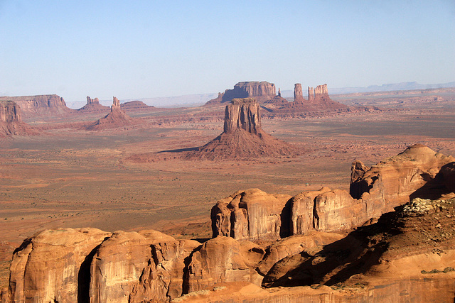
Monument Valley 19th September 2011
Flying over Lake Powell,Arizona,USA 19th September…
The Glen Canyon Dam from the Air 19th September 20…
Arikara Indian Memorial Little Bighorn Nationa Mon…
Lakota Sioux Indian Memorial Little Bighorn Nation…
Crazy Horse Memorial South Dakota USA 9th Septembe…
Crazy Horse Memorial South Dakota USA 9th Septembe…
Crazy Horse Memorial.What the Finished monument wi…
Mount Rushmore National Memorial South Dakota USA…
Mount Rushmore National Memorial,South Dakota USA…
Deadwood South Dakota USA 10th September 2011
Deadwood main street South Dakota USA 10th Septemb…
American Trucker
Seligman,Arizona Route 66
Grand Teton Peak from The Snake River,Teton Nation…
Broken Top Mountain,Bighorn National Forest,Wyomin…
Memorial Marker on Last Stand Hill,Little Bighorn…
Indian Combatant Marker Stone,Little Bighorn Battl…
US Soldier 7th Cavalry Marker Stone,Little Bighorn…
US Army Memorial on Last Stand Hill,Little Bighorn…
Yellowstone Lower Falls 308ft from Artist Point,Ye…
Grand Teton Peak from Jenny Lake,Grand Teton Natio…
Bryce Amphitheater from Bryce Point,Bryce Canyon N…
Grand Canyon from Mather Point,Arizona,USA 19th Se…
Location
See also...
Keywords
Authorizations, license
-
Visible by: Everyone -
All rights reserved
-
277 visits
Flying over Monument Valley ,Arizona/Utah,USA 19th September 2011


Monument Valley (Navajo: Tsé Biiʼ Ndzisgaii, meaning valley of the rocks) is a region of the Colorado Plateau characterized by a cluster of vast sandstone buttes, the largest reaching 1,000 ft (300 m) above the valley floor. It is located on the Arizona–Utah border (around 36°59′N 110°6′WCoordinates: 36°59′N 110°6′W), near the Four Corners area. The valley lies within the range of the Navajo Nation Reservation and is accessible from U.S. Highway 163.
Monument Valley has been featured in many forms of media since the 1930s. Director John Ford used the location for a number of his best-known films, and thus, in the words of critic Keith Phipps, "its five square miles [13 square kilometers] have defined what decades of moviegoers think of when they imagine the American West."
The area is part of the Colorado Plateau. The elevation of the valley floor ranges from 5,000 to 6,000 feet (1,500 to 1,800 m) above sea level. The floor is largely siltstone of the Cutler Group, or sand derived from it, deposited by the meandering rivers that carved the valley. The valley's vivid red color comes from iron oxide exposed in the weathered siltstone. The darker, blue-gray rocks in the valley get their color from manganese oxide.
The buttes are clearly stratified, with three principal layers. The lowest layer is the Organ Rock Shale, the middle is de Chelly Sandstone, and the top layer is the Moenkopi Formation capped by Shinarump Conglomerate. The valley includes large stone structures including the famed "Eye of the Sun".
Between 1945 and 1967, the southern extent of the Monument Upwarp was mined for uranium, which occurs in scattered areas of the Shinarump Conglomerate; vanadium and copper are associated with uranium in some deposits.
Ste has particularly liked this photo
- Keyboard shortcuts:
Jump to top
RSS feed- Latest comments - Subscribe to the comment feeds of this photo
- ipernity © 2007-2024
- Help & Contact
|
Club news
|
About ipernity
|
History |
ipernity Club & Prices |
Guide of good conduct
Donate | Group guidelines | Privacy policy | Terms of use | Statutes | In memoria -
Facebook
Twitter

one for my fav's with a Y.S
Best wishes ... Steve
Alan Drury club has replied to SteSign-in to write a comment.