

Earthwatcher's photos with the keyword: Rickets Head

Rickets Head Black Cliff Colliery tip and Newgale
| 02 Apr 2019 |
|
|
|
Nolton Haven to Newgale
The small Nolton-Newgale coalfield is separated by faulting from the main Pembrokeshire coalfield. It lies mostly within Pennant Sandstone Formation of the Upper Coal Measures rocks.
This northward view from the coast path from Rickets Head shows Newgale Sands in the background. On the right of the photo, behind the fence is a spoil heap in the vicinity of the shaft of Black Cliff (Rickets Head) Colliery which worked the Black Cliff Vein.
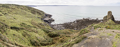
Rickets Head south mining activity panorama
| 02 Apr 2019 |
|
Nolton Haven to Newgale
The small Nolton-Newgale coalfield is separated by faulting from the main Pembrokeshire coalfield. It lies mostly within Pennant Sandstone Formation of the Upper Coal Measures rocks.
This southward panoramic view from the coast path shows Rickets Head on the right and St Brides Bay in the background. The present-day profile of the headland is a result of former coal mining activity and the removal of overburden to access the Rickets Head Vein coal which cropped out at the base of the sandstone which comprises the up-standing pillar of rock.
The coast path climbs up from Rickets Head over the disturbed ground and spoil heaps visible in the foreground.
On the left of the photo in the flatter grassy area, are old shafts and degraded, grassed-over, spoil heaps of Rickets Head Colliery which worked the underlying Black Cliff Vein.
Stratigraphically, the rocks of Rickets Head are the highest (youngest) in the Carboniferous sequence of the Pembrokeshire coalfields.
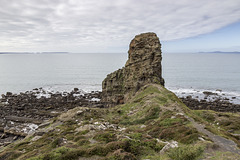
Rickets Head end-on view
| 02 Apr 2019 |
|
Nolton Haven to Newgale
The small Nolton-Newgale coalfield is separated by faulting from the main Pembrokeshire coalfield. It lies mostly within Pennant Sandstone Formation of the Upper Coal Measures rocks.
An end-on, westerly view of Rickets Head with St Brides Bay in the background. The present-day profile of the headland is a result of former coal mining activity and the removal of overburden to access the Rickets Head Vein coal which cropped out at the base of the sandstone which comprises the up-standing pillar of rock.
Stratigraphically, the rocks of Rickets Head are the highest (youngest) in the Carboniferous sequence of the Pembrokeshire coalfields.
The coast path climbs up over the disturbed ground and spoil heaps visible in the foreground.

Rickets Head north mining activity panorama
| 02 Apr 2019 |
|
Nolton Haven to Newgale
The small Nolton-Newgale coalfield is separated by faulting from the main Pembrokeshire coalfield. It lies mostly within Pennant Sandstone Formation of the Upper Coal Measures rocks.
This northward panoramic view from the coast path shows Rickets Head. The westerly, seaward, dip of the strata (approx 20°) is well seen.The present-day profile of the headland is a result of former coal mining activity; the rounded gap in the centre of the photo is at least partly due to the removal of overburden to access the Rickets Head Vein coal.
On the right of the photo, behind the fence are old shafts and degraded, grassed-over, spoil heaps of Rickets Head Colliery which worked the underlying Black Cliff Vein.
Stratigraphically, the rocks of Rickets Head are the highest (youngest) in the Carboniferous sequence of the Pembrokeshire coalfields.
Jump to top
RSS feed- Earthwatcher's latest photos with "Rickets Head" - Photos
- ipernity © 2007-2026
- Help & Contact
|
Club news
|
About ipernity
|
History |
ipernity Club & Prices |
Guide of good conduct
Donate | Group guidelines | Privacy policy | Terms of use | Statutes | In memoria -
Facebook
X
