

Earthwatcher's photos with the keyword: geo:lat=54.117914
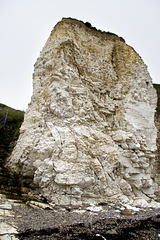
Disturbed Chalk stack at Selwicks Bay, Flamborough…
| 21 Jul 2009 |
|
This Chalk (Upper Cretaceous, Burnham Formation) stack at West Cliff, Selwicks Bay, Flamborough, East Yorkshire, is severely deformed by folding and thrusting as part of the east-west trending Howardian Hills-Flamborough Fault belt, which is magnificently exposed in the northern part of Selwicks Bay.
Structures such as this are rare in the Chalk of northern England, but in the Flamborough area, these E-W belts of disturbed Chalk have been recognised since 1829 during the early years of geological surveying in the UK.
A comprehensive account of the structural geology of the Flamborough area is given in:
Starmer, I.C. 1995. Deformation of the Upper Cretaceous Chalk at Selwicks Bay, Flamborough Head, Yorkshire: its significance in the structural evolution of north-east England and the North Sea Basin. Proceedings of the Yorkshire Geological Society, vol 50, part 3, pp 213-228.
Includes superb maps, sections and 3D block diagrams - well worth a read.
Jump to top
RSS feed- Earthwatcher's latest photos with "geo:lat=54.117914" - Photos
- ipernity © 2007-2026
- Help & Contact
|
Club news
|
About ipernity
|
History |
ipernity Club & Prices |
Guide of good conduct
Donate | Group guidelines | Privacy policy | Terms of use | Statutes | In memoria -
Facebook
X
