

Earthwatcher's photos with the keyword: geo:lat=53.177556
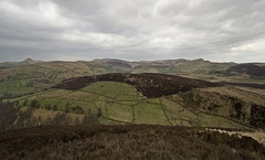
The Goyt Syncline from Roach End (x 2 vert. exagg.…
| 17 Sep 2007 |
|
Originally uploaded for the Guesswhere UK Group.
Very gloomy flat light when I took this. Must go back sometime.
This is a view looking north from Roach End in the Staffordshire Moorlands part of the Peak District National Park. The vertical scale has been exaggerated x2 in order to enhance the Namurian gritstone/shale dip and scarp topography and hence the geological structure. The Goyt Syncline can be seen running from the centre skyline down and off to the right. An eroded anticline is discernable on the left skyline, with the summit of Shutlingsloe dipping to the west (left).
Jump to top
RSS feed- Earthwatcher's latest photos with "geo:lat=53.177556" - Photos
- ipernity © 2007-2026
- Help & Contact
|
Club news
|
About ipernity
|
History |
ipernity Club & Prices |
Guide of good conduct
Donate | Group guidelines | Privacy policy | Terms of use | Statutes | In memoria -
Facebook
X
