

Earthwatcher's photos with the keyword: fault
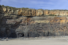
Cliff section east of Amroth 2
| 02 Apr 2019 |
|
Telpyn Point to Amroth
Between Amroth and Telpyn Point, magnificent cliff sections expose the upper Namurian sequence of deltaic channel-fill sandstones and intervening shale sequences.
About 1.5 km east of Amroth, this photo shows the sequence gently dipping to the west. At the top of the cliff are brown sandstones: the lowest in the Coal Measures sequence. Below this are dark mudstones of the Gastrioceras subcrenatum Marine Band which marks the base of the Coal Measures. This is underlain by the Telpyn Point Sandstone (formerly designated as the Upper Sandstone), the uppermost main sandstone in the Namurian, and originally known as the 'Farewell Rock', so called because exploratory boreholes and shafts for coal penetrating the sandstone would no longer encounter any workable coals. Underlying the sandstone is a shale sequence.
See notes for details.
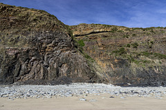
West of Telpyn Point - fault in Telpyn Point Sands…
| 02 Apr 2019 |
|
Telpyn Point to Amroth
Between Amroth and Telpyn Point, magnificent cliff sections expose the upper Namurian sequence of deltaic channel-fill sandstones and intervening shale sequences.
This photo shows a normal fault (in the centre) downthrowing approx.10 m to the east (right).
The dark band just below the top of the cliff on the eastern side is a thin coaly horizon. Overlying this are mudstones of the Gastrioceras subcrenatum Marine Band which marks the base of the Coal Measures.
The main part of the cliff section is in the Telpyn Point Sandstone (formerly designated as the Upper Sandstone), the uppermost main sandstone in the Namurian, and originally known as the 'Farewell Rock', so called because exploratory boreholes and shafts for coal penetrating the sandstone would no longer encounter any workable coals. Underlying the sandstone is a shale sequence.
See notes for details.
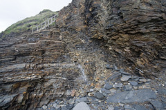
Fault zone at The Strangles
| 02 Oct 2009 |
|
A small fault in the Crackington Formation (upper Carboniferous) at The Strangles, near Crackington Haven, north Cornwall.
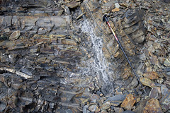
Fault zone detail at The Strangles
| 02 Oct 2009 |
|
Detail of the small fault and fault breccia in the Crackington Formation (upper Carboniferous) at The Strangles, near Crackington Haven, north Cornwall.
Plunging chevron folds at Northcott Mouth
| 08 Nov 2009 |
|
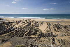
Bedding traces of plunging chevron folds in the Bude Formation (upper Carboniferous) sandstones in the beach at Northcott Mouth, near Bude, north Cornwall. Two faults cut the bedding traces in the lower right quadrant. Synclines 'V' towards the camera; anticlines 'V' towards the sea. The plunge is seawards.
What does this mean?
Here's a simple model - fold a sheet of thin card into a few zig-zag folds so it becomes angularly corrugated like a fan. Open the card out a little and hold it horizontally. Look along the length of the folds. That's the situation with no plunge. Now, tilt the card slightly downwards at the far end, still continuing to look down the length of the folds. The tilt you have applied is the 'plunge' of the fold set.
Now, keeping that same gentle angle of tilt, partially immerse the folded, tilted card into a bowl of water. Quickly, before it gets too soggy and distorts, notice the pattern of the water-line where the card intersects the water surface: a series of elongated zig-zags just like these on the flat surface of the beach. The steeper the angle of plunge, the shorter the elongation and vice versa .
Selwicks Bay panorama
| 27 Jul 2009 |
|
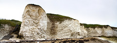
Disturbed Chalk in the Howardian Hills-Flamborough Fault belt at West Cliff, Selwicks Bay, Flamborough, East Yorkshire.
A panoramic stitching of 4 photos, using Canon's Photostitch software.
Disturbed Chalk stack at Selwicks Bay, Flamborough…
| 21 Jul 2009 |
|
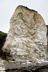
This Chalk (Upper Cretaceous, Burnham Formation) stack at West Cliff, Selwicks Bay, Flamborough, East Yorkshire, is severely deformed by folding and thrusting as part of the east-west trending Howardian Hills-Flamborough Fault belt, which is magnificently exposed in the northern part of Selwicks Bay.
Structures such as this are rare in the Chalk of northern England, but in the Flamborough area, these E-W belts of disturbed Chalk have been recognised since 1829 during the early years of geological surveying in the UK.
A comprehensive account of the structural geology of the Flamborough area is given in:
Starmer, I.C. 1995. Deformation of the Upper Cretaceous Chalk at Selwicks Bay, Flamborough Head, Yorkshire: its significance in the structural evolution of north-east England and the North Sea Basin. Proceedings of the Yorkshire Geological Society, vol 50, part 3, pp 213-228.
Includes superb maps, sections and 3D block diagrams - well worth a read.
Disturbed Chalk at Langtoft Quarry, East Yorkshire…
| 20 Jul 2009 |
|
Originally uploaded for the Guesswhere UK group.
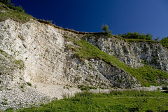
This is a view of the old and rather overgrown Chalk quarry just south of Langtoft, in East Yorkshire.
Normally the Chalk in East Yorkshire is horizontally bedded or nearly so. But at this quarry the locally steep dips (> 50°) are due to the east-west trending Howardian Hills-Flamborough Fault belt. This is magnificently exposed on the coast at Selwicks Bay, near Flamborough Head:
In the Flamborough area, these E-W belts of disturbed Chalk have been recognised since 1829 during the early years of geological surveying in the UK.
Selwicks Bay faults
| 27 Jul 2009 |
|
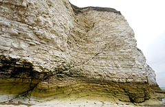
Small faults cutting the Chalk at the north end of Selwicks Bay, Flamborough. The Chalk here is disturbed by the Howardian Hills-Flamborough fault belt, although this particular bit is not particularly deformed.
I also liked the colours and textures in the lower part of the cliff.
Molk Hole arch
| 27 Jul 2009 |
|
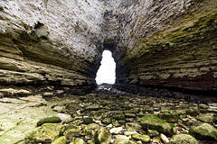
Molk Hole is an intriguing irregularly-shaped inlet at the north end of Selwicks Bay, Flamborough. A fascinating area of Chalk cliffs, sea caves and arches, hollowed out along fault and fracture zones in part of the Howardian Hills-Flamborough Fault Belt.
A lovely place to explore at low tide.
Molk Hole 1
| 27 Jul 2009 |
|
|
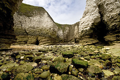
Molk Hole is an intriguing irregularly-shaped inlet at the north end of Selwicks Bay, Flamborough. A fascinating area of Chalk cliffs, sea caves and arches, hollowed out along fault and fracture zones in part of the Howardian Hills-Flamborough Fault Belt.
A lovely place to explore at low tide.
Molk Hole 2
| 27 Jul 2009 |
|
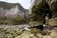
Molk Hole is an intriguing irregularly-shaped inlet at the north end of Selwicks Bay, Flamborough. A fascinating area of Chalk cliffs, sea caves and arches, hollowed out along fault and fracture zones in part of the Howardian Hills-Flamborough Fault Belt.
A lovely place to explore at low tide.
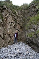
Stackpole Fault
| 26 Sep 2008 |
|
The Stackpole Fault exposed in a small cove at Stackpole Quay, Pembrokeshire. The camera location of the previous photo in the photostream was in the notch at the top of the photo.
Jan is standing just to the left of the fault plane, which consists of a jumbled smash-zone of fragmented limestone recemented with calcite. To the left of the fault plane, the rocks are dipping northwards at about 45°. There is a well-developed, nearly vertical set of fractures (parallel to Jan). These are axial planar cleavage developed around the Stackpole Quay anticline, but have probably been amplified as pinnate cleavage by the proximity and movement of the Stackpole Fault. (A bit like trying to plane a piece of wood against the grain - the plane 'chatters' and you get a rough surface, not a smooth one)
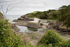
Stackpole Quay, Pembrokeshire
| 26 Sep 2008 |
|
As well as being a very picturesque spot, Stackpole Quay is really interesting in terms of structural geology. The rocks are Carboniferous Limestone which have been folded and faulted. Of particular interest is the Stackpole Fault, which is a tear fault or strike-slip fault. This means that rocks on either side of the fault are shifted mainly horizontally relative to each other, rather than vertically. Here, the off-set across the fault is about 100 metres to the right (dextral). In some ways the Stackpole Fault is like a miniature version of California's San Andreas Fault, although the mechanism driving the fracture is different.
In this southwards view, the Stackpole Fault can be seen in the quarry face in the distance. It runs towards the camera, causing the outcrop of rocks in the harbour just to the right of the boat to be truncated suddenly. The camera location (i.e. me) is directly on the fault.
The main Stackpole Quay anticline axis is located in the slipway in the foreground on the RH side of the fault, but is truncated by the fault and off-set 100 m southwards to reappear at the far end of the harbour wall on the LH side of the fault.
Hmm... it takes a lot of words to explain. It's much easier to understand when you go there and see it for yourself :-)
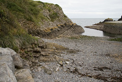
Stackpole Quay, Pembrokeshire
| 26 Sep 2008 |
|
Another view of the rocks - Carboniferous Limestone - at Stackpole Quay, Pembrokeshire.
In the left foreground, the crest of the Stackpole Quay anticline is just visible. In the left background, the northerly dip of the rocks does not match with the foreground. This is because the Stackpole Fault runs across the photo from L to R with different structures visible on either side. On the far side of the fault, the axis of the Stackpole Quay anticline is offset by 100 metres to the right (south).
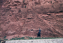
Normal Faults in the Budleigh Salterton Pebble Bed…
| 26 Dec 2007 |
|
"Geology student gets red card for her 'art' work!"
Originally uploaded as No.5 of a jolly selection of Xmas Guesswhere UK puzzles.
A view of the cliffs just west of Budleigh Salterton, showing the eponymous Pebble Beds (basal Triassic age), overlain by the Otter Sandstone. The sequence is then cut by four small normal (i.e. tensional) faults.
These rocks were deposited in desert conditions by intermittent torrential floods, perhaps in a wadi type of environment.
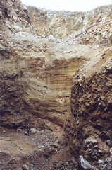
Dirtlow Rake exposed vein with slickensides
| 08 Jun 2007 |
|
By 1993, the reworking of Dirtlow Rake for fluorite and barytes had just about reached its maximum depth. This photo shows the vein itself exposed in the SW part of the quarry, probably close to the former Hollandtwine lead mine. My wife standing in the bottom of the excavation indicates the scale (see note).
Of note are the horizontal slickensides ('scratch marks') on the side of the vein. This is at the boundary with the host rock and vein and provides good evidence of relative horizontal movement; and demonstrates that this vein at least was emplaced along a fault line which had mostly horizontal displacement - a strike-slip or wrench fault, a bit like a miniature San Andreas fault. In all probability, most of the WSW-ENE trending mineral veins in this part of the Peak District have a similar origin.
Taken with a Zenit E camera; scanned from a Kodacolor print.
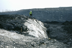
Where Brookhouse Colliery used to be
| 02 Jul 2006 |
|
A view of 'Pithouse West' opencast coal site taken on 12th March 1993 looking northwards roughly in the area where Brookhouse Colliery (deep mine) used to be.
The opencast mining was carried out to recover shallow coal from the site of the former colliery: coal too thin and shallow to have been mined by conventional underground methods. The former colliery site also included waste tips, slurry lagoons and coke ovens, all of which were removed and their remains buried deep within the backfill of the opencast site.
The picture shows the Clowne coal seam with the overburden removed, ready for lifting and loading into trucks. The white scar in the middle of the picture is a fault - a natural fracture in the rocks displacing the coal seam down to the right-hand side of the picture.
After the opencast site was finished in the mid-1990s, the site was restored to form part of the Rother Valley Country Park.
Scanned from Kodachrome 64 transparency film.
Jump to top
RSS feed- Earthwatcher's latest photos with "fault" - Photos
- ipernity © 2007-2026
- Help & Contact
|
Club news
|
About ipernity
|
History |
ipernity Club & Prices |
Guide of good conduct
Donate | Group guidelines | Privacy policy | Terms of use | Statutes | In memoria -
Facebook
X
