

Earthwatcher's photos with the keyword: Stackpole Quay
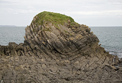
Syncline in Middle Cove islet, Stackpole Quay, Pem…
| 25 Sep 2008 |
|
This is a view of the plunging syncline in the small islet in Middle Cove, just north of Stackpole Quay, Pembrokeshire. The fold is developed in Carboniferous Limestone, with a plunging axis trending approximately ESE-WNW, dipping easterly.
The fold style is mostly concentric, but the 'space problem' in the centre of the fold has been accommodated by small-scale thrusting and crumpling, and additional movement taking place along bedding planes.

Stackpole Middle Cove
| 26 Sep 2008 |
|
Another view of the Middle Cove islet at Stackpole Quay, Pembrokeshire, formed of Carboniferous Limestone folded into a plunging syncline. In this photo, the axis of the syncline crosses the islet from L-R with a gentle plunge easterly (R).
Cliffs of Devonian age Old Red Sandstone are visible in the background.
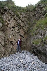
Stackpole Fault
| 26 Sep 2008 |
|
The Stackpole Fault exposed in a small cove at Stackpole Quay, Pembrokeshire. The camera location of the previous photo in the photostream was in the notch at the top of the photo.
Jan is standing just to the left of the fault plane, which consists of a jumbled smash-zone of fragmented limestone recemented with calcite. To the left of the fault plane, the rocks are dipping northwards at about 45°. There is a well-developed, nearly vertical set of fractures (parallel to Jan). These are axial planar cleavage developed around the Stackpole Quay anticline, but have probably been amplified as pinnate cleavage by the proximity and movement of the Stackpole Fault. (A bit like trying to plane a piece of wood against the grain - the plane 'chatters' and you get a rough surface, not a smooth one)

Stackpole Quay, Pembrokeshire
| 26 Sep 2008 |
|
As well as being a very picturesque spot, Stackpole Quay is really interesting in terms of structural geology. The rocks are Carboniferous Limestone which have been folded and faulted. Of particular interest is the Stackpole Fault, which is a tear fault or strike-slip fault. This means that rocks on either side of the fault are shifted mainly horizontally relative to each other, rather than vertically. Here, the off-set across the fault is about 100 metres to the right (dextral). In some ways the Stackpole Fault is like a miniature version of California's San Andreas Fault, although the mechanism driving the fracture is different.
In this southwards view, the Stackpole Fault can be seen in the quarry face in the distance. It runs towards the camera, causing the outcrop of rocks in the harbour just to the right of the boat to be truncated suddenly. The camera location (i.e. me) is directly on the fault.
The main Stackpole Quay anticline axis is located in the slipway in the foreground on the RH side of the fault, but is truncated by the fault and off-set 100 m southwards to reappear at the far end of the harbour wall on the LH side of the fault.
Hmm... it takes a lot of words to explain. It's much easier to understand when you go there and see it for yourself :-)
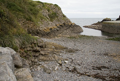
Stackpole Quay, Pembrokeshire
| 26 Sep 2008 |
|
Another view of the rocks - Carboniferous Limestone - at Stackpole Quay, Pembrokeshire.
In the left foreground, the crest of the Stackpole Quay anticline is just visible. In the left background, the northerly dip of the rocks does not match with the foreground. This is because the Stackpole Fault runs across the photo from L to R with different structures visible on either side. On the far side of the fault, the axis of the Stackpole Quay anticline is offset by 100 metres to the right (south).
Jump to top
RSS feed- Earthwatcher's latest photos with "Stackpole Quay" - Photos
- ipernity © 2007-2026
- Help & Contact
|
Club news
|
About ipernity
|
History |
ipernity Club & Prices |
Guide of good conduct
Donate | Group guidelines | Privacy policy | Terms of use | Statutes | In memoria -
Facebook
X
