Pembrokeshire
Folder: Wales
Photos taken in Pembrokeshire, the county in the bottom left-hand corner of Wales
Gravel Bay - millipede-like burrows in Moor Cliffs…
| |
|
|
Freshwater West, Gravel Bay and East Pickard Bay
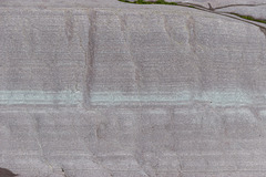
Moor Cliffs Formation in Gravel Bay.
This photo shows a close-up view of the light purple sandstone bed with greenish laminae seen in the previous photo. The darker perpendicular features in the sandstone are trace-fossil Beaconites burrows. Having previously been tentatively ascribed to worm burrows or lung-fish burrows, they are now thought to have been made by primitive millipede-like animals.
The bed is approx. 50 cm thick (top to bottom) in this photo.
Background:
The Moor Cliffs Formation overlies the Freshwater East conglomerates, seen in previous photos, and spans the boundary between the Silurian and Devonian periods. It consists of red mudstones and siltstones with occasional thin sandstone beds. These were deposited on a low-reflief floodplain at the edge of an arid continental margin, the sandstones being deposited by seasonal braided streams, the muds and silts deposited in ephemeral marginal lakes. When not inundated, the muds and silts developed carbonate-rich calcrete (caliche) soil horizons along dessication cracks, burrows and early plant root systems.
Gravel Bay - Moor Cliffs Formation 2
| |
|
|
Freshwater West, Gravel Bay and East Pickard Bay
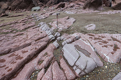
Moor Cliffs Formation in Gravel Bay.
This photo shows a closer view of the wave cut platform in the Moor Cliffs Formation at the western end of Gravel Bay. A light purple sandstone bed with greenish laminae is seen in the centre of the photo with red mudstones below (left) and above (right). The darker perpendicular features in the sandstone are trace-fossil Beaconites burrows. Having previously been tentatively ascribed to worm burrows or lung-fish burrows, they are now thought to have been made by primitive millipede-like animals.
The white mottling in the mudstones indicate extensive calcrete soil horizons. The sequence is dipping to the north (right) at approx. 60°.
The walking stick is about 0.9 m long.
Background:
The Moor Cliffs Formation overlies the Freshwater East conglomerates, seen in previous photos, and spans the boundary between the Silurian and Devonian periods. It consists of red mudstones and siltstones with occasional thin sandstone beds. These were deposited on a low-reflief floodplain at the edge of an arid continental margin, the sandstones being deposited by seasonal braided streams, the muds and silts deposited in ephemeral marginal lakes. When not inundated, the muds and silts developed carbonate-rich calcrete (caliche) soil horizons along dessication cracks, burrows and early plant root systems.
Gravel Bay - Moor Cliffs Formation 1
| |
|
Freshwater West, Gravel Bay and East Pickard Bay
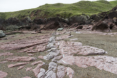
Moor Cliffs Formation in Gravel Bay.
This photo shows the wave cut platform in the Moor Cliffs Formation at the western end of Gravel Bay. A light purple sandstone bed is seen in the centre of the photo with red mudstones below (left) and above (right). The white mottling towards the right is a particularly well-developed calcrete horizon. The sequence is dipping to the north (right) at approx. 60°.
The walking stick is about 0.9 m long.
Background:
The Moor Cliffs Formation overlies the Freshwater East conglomerates, seen in previous photos, and spans the boundary between the Silurian and Devonian periods. It consists of red mudstones and siltstones with occasional thin sandstone beds. These were deposited on a low-reflief floodplain at the edge of an arid continental margin, the sandstones being deposited by seasonal braided streams, the muds and silts deposited in ephemeral marginal lakes. When not inundated, the muds and silts developed carbonate-rich calcrete (caliche) soil horizons along dessication cracks, burrows and early plant root systems.
Freshwater West walkies
| |
|
|
Freshwater West, Gravel Bay and East Pickard Bay
It was rather a dull morning, with a moody sky over the broad sweep of Freshwater West in south Pembrokeshire, viewed from Gravel Bay. This couple and their dog came along at just the right moment.
Spray haze over Freshwater West
| |
|
|
Freshwater West, Gravel Bay and East Pickard Bay
It was rather a dull morning, with a moody sky over the beach at low tide. This is looking south from Gravel Bay at the northern end of the broad sweep of Freshwater West in south Pembrokeshire. A beach-hugging haze of spray adds to the minimalist softness of the scene.
Moody sky over Freshwater West
| |
|
|
|
Freshwater West, Gravel Bay and East Pickard Bay
Although it was a dull morning, with a moody sky over the beach at low tide, I rather liked this minimalist shoreline view. This is looking south from Gravel Bay at the northern end of the broad sweep of Freshwater West in south Pembrokeshire.
Conglomerate at Gravel Bay: close-up view 2
| |
|
|
Freshwater West, Gravel Bay and East Pickard Bay
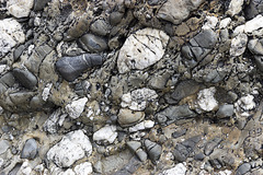
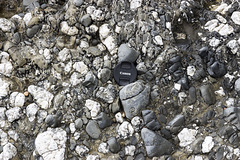
Another close-up view of a conglomerate in the Freshwater East Formation (note name) at Gravel Bay, situated at the northern end of the large Freshwater West bay in south Pembrokeshire. The view is closely adjacent to the previous photo but without the lens cap for scale, as I didn't want it to distract from the lovely textures in this rock.
The vertical dimension of the photo is about 40 cm.
The Freshwater East Formation marks the beginning of 'Old Red Sandstone' type of sediments, formerly believed to be at the base of the Devonian, but now assigned to the uppermost Silurian. The pebbles and cobbles in the conglomerates mostly consist of white vein quartz and quartzite, grey sandstones and darker sitstones. These were depositied in an alluvial fan settting on a shallow floodplain in increasingly arid conditions.
Conglomerate at Gravel Bay: close-up view 1
| |
|
Freshwater West, Gravel Bay and East Pickard Bay
Close-up view of a conglomerate in the Freshwater East Formation (note name) at Gravel Bay, situated at the northern end of the large Freshwater West bay in south Pembrokeshire. The lens cap is 72 mm in diameter.
The Freshwater East Formation marks the beginning of 'Old Red Sandstone' type of sediments, formerly believed to be at the base of the Devonian, but now assigned to the uppermost Silurian. The pebbles and cobbles in the conglomerates mostly consist of white vein quartz and quartzite, grey sandstones and darker sitstones. These were depositied in an alluvial fan settting on a shallow floodplain in increasingly arid conditions.
Conglomerates at Gravel Bay
| |
|
|
|
Freshwater West, Gravel Bay and East Pickard Bay
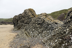
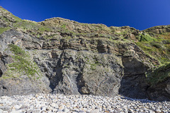
Massive conglomerates and grey sandstones dipping steeply to the north (right) of the Freshwater East Formation (note name) at Gravel Bay, situated at the northern end of the large Freshwater West bay in south Pembrokeshire. The walking stick is 0.9 m long.
The Freshwater East Formation marks the beginning of 'Old Red Sandstone' type of sediments, formerly believed to be at the base of the Devonian, but now assigned to the uppermost Silurian. The pebbles and cobbles in the conglomerates mostly consist of white vein quartz and quartzite, grey sandstones and darker sitstones. These were depositied in an alluvial fan settting on a shallow floodplain in increasingly arid conditions.
The Settlands sand trees 3
| |
|
|
|
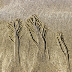
I was intrigued by the 'forests' created in the sand by the rivulets of water draining from The Settlands beach near Little Haven, Pembrokeshire.
The Settlands sand trees 2
| |
|
|
|
I was intrigued by the 'forests' created in the sand by the rivulets of water draining from The Settlands beach near Little Haven, Pembrokeshire.
The Settlands sand trees 1
| |
|
|
I was intrigued by the 'forests' created in the sand by the rivulets of water draining from The Settlands beach near Little Haven, Pembrokeshire.
Little Settlands - inverted thin coals and disturb…
| |
|
Structural geology of Little Haven and The Settlands
The cliffs from Little Haven to Broad Haven (and northward) display a spectacular range of geological structures, folding, faulting and thrusting, mainly in the Lower Coal Measures. The relatively weak mudstone and shale-dominated sequences show much incompetent deformation: tight, thrusted and overturned folds, in contrast to the thicker, stronger, sandstones which have formed relatively open and concentric folds.
Immediately north of The Rain headland is a small embayment: 'Little Settlands'. Here, a chaotic looking series of disturbed bedding and downward-facing small folds are in contact with a thin coal. The whole sequence is inverted, the inversion being a continuation of the overturned structure seen on The Rain and the northern end of the main Settlands bay.
The coal is completely inverted ('up' is to down to the left). Three thin leaves of coal are visible here. Furthest to the left is the true upper leaf approx. 8 cm thick. This is underlain by pale grey seatearth (behind the walking stick), then another two thin bands of coal one by the stick handle and another beyond that. There appears to be a shear plane to the right of the stick handle; the coal leaf which uppermost in the photo may be a structural duplication repeat of the 8 cm coal leaf. See notes.
The stick is 90 cm long.
Little Settlands - incompetent deformation 2
| |
|
Structural geology of Little Haven and The Settlands
The cliffs from Little Haven to Broad Haven (and northward) display a spectacular range of geological structures, folding, faulting and thrusting, mainly in the Lower Coal Measures. The relatively weak mudstone and shale-dominated sequences show much incompetent deformation: tight, thrusted and overturned folds, in contrast to the thicker, stronger, sandstones which have formed relatively open and concentric folds.
Immediately north of The Rain headland is a small embayment: 'Little Settlands'. Here, a chaotic looking series of disturbed bedding and downward-facing small folds are in contact with a thin coal. The whole sequence is inverted, the inversion being a continuation of the overturned structure seen on The Rain and the northern end of the main Settlands bay.
Downward-facing means that the way-up, younging direction, of the folds is downwards, rather than the normal upwards. The evidence for the way up is provided by small scale (too small to be seen clearly in this photo) sedimentary slump and load casts on the bases of sandy layers within the predominantly shale and mudstone sequence. The inverted folds are thought to have been initiated immediately prior to the main folding and thrusting event.
This shows a closer view of the downward-facing fold in the previous photo. The younging direction is down towards the lower right, so the structure spanned by the walking stick is actually an overturned and inverted syncline.
The stick is 90 cm long.
Little Settlands - incompetent deformation 1
| |
|
Structural geology of Little Haven and The Settlands
The cliffs from Little Haven to Broad Haven (and northward) display a spectacular range of geological structures, folding, faulting and thrusting, mainly in the Lower Coal Measures. The relatively weak mudstone and shale-dominated sequences show much incompetent deformation: tight, thrusted and overturned folds, in contrast to the thicker, stronger, sandstones which have formed relatively open and concentric folds.
Immediately north of The Rain headland is a small embayment: 'Little Settlands'. Here, a chaotic looking series of disturbed bedding and downward-facing small folds are in contact with a thin coal. The whole sequence is inverted, the inversion being a continuation of the overturned structure seen on The Rain and the northern end of the main Settlands bay, e.g. on the left in the previous photo here:
Downward-facing means that the way-up, younging direction, of the folds is downwards, rather than the normal upwards. So the structure at the lower right (see note) which looks like an overturned anticline is actually an inverted syncline. The evidence for the way up is provided by small scale (too small to be seen clearly in this photo) sedimentary slump and load casts on the bases of sandy layers within the predominantly shale and mudstone sequence. The inverted folds are thought to have been initiated immediately prior to the main folding and thrusting event.
The coal is completely inverted ('up' is to down to the left) and separated from the inverted folds by a prominent shear plane just below the bottom of the walking stick and running up towards the upper left.
The stick is 90 cm long.
Little Haven - The Settlands; detail of overturned…
| |
|
|
Structural geology of Little Haven and The Settlands
The cliffs from Little Haven to Broad Haven (and northward) display a spectacular range of geological structures, folding, faulting and thrusting, mainly in the Lower Coal Measures. The relatively weak mudstone and shale-dominated sequences show much incompetent deformation: tight, thrusted and overturned folds, in contrast to the thicker, stronger, sandstones which have formed relatively open and concentric folds.
This is a close-up view of the prominent overturned, nearly recumbent, chevron-style anticline at the northern end of The Settlands. The relatively weak mudstone and shale sequence has deformed incompetently, with some thickening in the hinge zone.The dark shale bed just below the centre of the photo is at the horizon of the Amman Marine Band.
The overturned northern limb of the fold is separated from the nearly horizontal upper limb by a near-horizontal thrust. Below this thrust, disturbed, separate, repeated portions of the hinge zone are visible, one of which has developed axial planar cleavage in the grey seatearth with brown ironstone bands and nodules.
Above the anticline, another significant, higher, thrust has carried more sandy beds over the top.
See notes for individual descriptions of areas on the photo.
Little Haven - The Settlands; detail of incompeten…
| |
|
|
Structural geology of Little Haven and The Settlands
The cliffs from Little Haven to Broad Haven (and northward) display a spectacular range of geological structures, folding, faulting and thrusting, mainly in the Lower Coal Measures. The relatively weak mudstone and shale-dominated sequences show much incompetent deformation: tight, thrusted and overturned folds, in contrast to the thicker, stronger, sandstones which have formed relatively open and concentric folds.
This is a closer view of the complexly folded and thrusted sequence in the central part of the The Settlands. The relatively weak mudstone and shale sequence has deformed incompetently.
In the centre, an anticline with a vertical/slightly overturned northern limb is separated by a near-horizontal thrust from the gently dipping shales just above the beach pebbles.
To the right, a curved slice of siltstones/thin sandstones is itself thrusted over the horizontal thrust. The dark shale bed in the centre of the photo is approximately at the horizon of the Amman Marine Band, which can be followed, despite the structural complexity, northwards (left) to The Rain headland.
See notes for individual descriptions of areas on the photo.
Little Haven - The Settlands; detail of incompeten…
| |
|
Structural geology of Little Haven and The Settlands
The cliffs from Little Haven to Broad Haven (and northward) display a spectacular range of geological structures, folding, faulting and thrusting, mainly in the Lower Coal Measures. The relatively weak mudstone and shale-dominated sequences show much incompetent deformation: tight, thrusted and overturned folds, in contrast to the thicker, stronger, sandstones which have formed relatively open and concentric folds.
This is a closer view of the complexly folded and thrusted sequence in the central part of the The Settlands. The reatively weak mudstone and shale sequence has deformed incompetently, in stark contrast to the small anticline a few metres to the south (right) in the previous photo. The dark shale bed in the centre of the photo is approximately at the horizon of the Amman Marine Band, which can be followed, despite the structural complexity, northwards (left) to The Rain headland.
See notes for individual descriptions of areas on the photo.
Jump to top
RSS feed- Latest items - Subscribe to the latest items added to this album
- ipernity © 2007-2024
- Help & Contact
|
Club news
|
About ipernity
|
History |
ipernity Club & Prices |
Guide of good conduct
Donate | Group guidelines | Privacy policy | Terms of use | Statutes | In memoria -
Facebook
Twitter

