Cornwall
Photos taken in Cornwall
The Strangles recumbent fold 2
| |
|
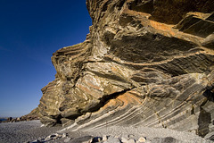
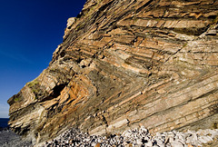
A recumbent fold with well-developed, near-horizontal, axial planar cleavage in a shaly horizon of the Crackington Formation (upper Carboniferous) at The Strangles cliff, near Crackington Haven, north Cornwall.
The Strangles cliff
| |
|
Originally uploaded as a clue to a Guesswhere UK photo.
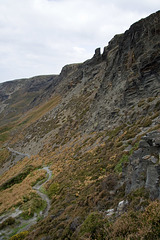
This is a view of the upper cliff overlooking The Strangles, near Crackington Haven, north Cornwall. The cliff is comprised of the Crackington Formation: upper Carboniferous turbidites and shales, which have been subjected to intense folding and a near-horizontal axial-planar, slaty cleavage is well developed in the shaly parts of the sequence, as in this location. The cliff has been extensively quarried in the past for slates.
The Strangles cliffs, near Crackington Haven, Nort…
| |
|
Originally uploaded for the Guesswhere UK group.
This is a view of the upper cliff overlooking The Strangles, near Crackington Haven, north Cornwall. The cliff is comprised of the Crackington Formation: upper Carboniferous turbidites and shales, which have been subjected to intense folding and a near-horizontal axial-planar, slaty cleavage is well developed in the shaly parts of the sequence, as in this location. The cliff has been extensively quarried in the past for slates.
Samphire Rock and Northern Door
| |
|
The Samphire Rock is the sea-stack in the lower left; Northern Door is the arch close to the centre. The Strangles cliff, near Crackington Haven, north Cornwall.
The Strangles recumbent fold couplet
| |
|
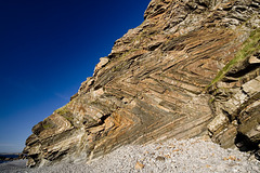
A recumbent fold couplet with well-developed, near-horizontal, axial planar cleavage in a shaly horizon of the Crackington Formation (upper Carboniferous) at The Strangles cliff, near Crackington Haven, north Cornwall.
Pentargon 2
| |
|
Just north-east of Boscastle, the short, steep-sided Pentargon valley ends abruptly, its waterfall plunging 120 ft over the sheer lip into the Pentargon inlet below. There are a number of these truncated valleys on the north Cornwall coast. Few of them extend far inland and often end with a spectacular, if small, waterfall over a vertical drop to the beach below.
Pentargon valley and waterfall
| |
|
Just north-east of Boscastle, the short, steep-sided Pentargon valley ends abruptly, its waterfall plunging 120 ft over the sheer lip into the Pentargon inlet below. There are a number of these truncated valleys on the north Cornwall coast. Few of them extend far inland and often end with a spectacular, if small, waterfall over a vertical drop to the beach below.
The rocks are shales with thin turbidite sandstones - part of the Crackington Formation (upper Carboniferous) - which are deformed into tight horizontal recumbent folds.
Photo taken from the spectacular South West Coastal Path, which follows the cliff indentations and gives tremendous views.
Pentargon blue
| |
|
Pentargon is a beautiful rocky inlet just north-east of Boscastle, on the coast of north Cornwall. Viewed here from the truncated lip.
Here, the short, steep-sided Pentargon valley ends abruptly, its waterfall plunging 120 ft over the sheer lip into the Pentargon inlet below. There are a number of these truncated valleys on the north Cornwall coast. Few of them extend far inland and often end with a spectacular, if small, waterfall over a vertical drop to the beach below.
On the edge - Pentargon waterfall
| |
|
The top of the Pentargon waterfall, taken from a rather precarious position just off the spectacular South West Coastal Path.
Just north-east of Boscastle, the short, steep-sided Pentargon valley ends abruptly, its waterfall plunging 120 ft over the sheer lip into the Pentargon inlet below. There are a number of these truncated valleys on the north Cornwall coast. Few of them extend far inland and often end with a spectacular, if small, waterfall over a vertical drop to the beach below.
The rocks are shales with thin turbidite sandstones - part of the Crackington Formation (upper Carboniferous) - which are deformed into tight horizontal recumbent folds.
Buckator cliffs, north Cornwall
| |
|
Taken from the spectacular South West Coastal Path, between Boscastle and Crackington Haven.
The rocks are shales with thin turbidite sandstones - part of the Crackington Formation (upper Carboniferous) - which are deformed into tight horizontal recumbent folds.
The coastal path follows the cliff indentations and gives tremendous views.
Millook Haven cliff detail 6
| |
|
Detail of part of the turbidite sequence of the Crackington Formation (upper Carboniferous) at Millook Haven, north Cornwall, lit by the late afternoon sun.
This photo shows alternating sandstone (pale) and shale bands on the inverted limb of one of the recumbent chevron folds. The compass-clinometer is located on the stratigraphic base of one of the sandstone bands, which displays a fining-up sequence (in this case downwards, since it is inverted). Just to the left of the compass-clinometer, the coarser sandstone base has slumped stratigraphically down (in this case appearing up) into the underlying muddy layer (now grey shale).
This shows how you can use sedimentary structures to deduce whether the rocks are the right way up, or whether as in this case, they have been subsequently turned upside-down.
Folded and inverted turbidites at Millook Haven, C…
| |
|
An unusual view of the intensely folded turbidite sequence in the Crackington Formation (upper Carboniferous) at Millook Haven, north Cornwall.
The northward-dipping limbs of the folds e.g. the striped sequence in the lower left quadrant are the inverted (upside-down) limbs.
Millook Haven cliff detail 5
| |
|
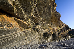
Cascades of recumbent chevron folds in the turbidite sequence of the Crackington Formation (upper Carboniferous) at Millook Haven, north Cornwall, lit by the late afternoon sun.
The northward-dipping (to the left) limbs of the folds are the inverted (upside-down) limbs.
Millook Haven cliff detail 4
| |
|
Cascades of recumbent chevron folds in the turbidite sequence of the Crackington Formation (upper Carboniferous) at Millook Haven, north Cornwall, lit by the late afternoon sun.
The northward-dipping (to the left) limbs of the folds are the inverted (upside-down) limbs.
Upside-down rocks at Millook Haven, Cornwall
| |
|
|
|
The is an unusual detail view of the rocks at Millook Haven, north Cornwall.
The striped rocks are turbidites belonging to the Crackington Formation (upper Carboniferous). Way-up structures in the sandstone bands such as fining-up sequences, small-scale slump structures, ripple marks and grooves, etc, demonstrate that these northward dipping rocks (part of the famous chevron fold sequence) have been inverted and are upside-down.
Millook Haven cliff detail 3
| |
|
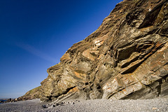
Cascades of recumbent chevron folds in the turbidite sequence of the Crackington Formation (upper Carboniferous) at Millook Haven, north Cornwall, lit by the late afternoon sun.
The northward-dipping (to the left) limbs of the folds are the inverted (upside-down) limbs.
Millook Haven cliff detail 2
| |
|
|
Cascades of recumbent chevron folds in the turbidite sequence of the Crackington Formation (upper Carboniferous) at Millook Haven, north Cornwall, lit by the late afternoon sun.
The northward-dipping (to the left) limbs of the folds are the inverted (upside-down) limbs.
The walking-stick in the lower middle is approx. 0.9 m long.
Millook Haven cliff detail 1
| |
|
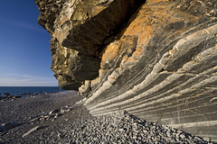
Cascades of recumbent chevron folds in the turbidite sequence of the Crackington Formation (upper Carboniferous) at Millook Haven, north Cornwall, lit by the late afternoon sun.
The northward-dipping (to the left) limbs of the folds are the inverted (upside-down) limbs.
Jump to top
RSS feed- Latest items - Subscribe to the latest items added to this album
- ipernity © 2007-2025
- Help & Contact
|
Club news
|
About ipernity
|
History |
ipernity Club & Prices |
Guide of good conduct
Donate | Group guidelines | Privacy policy | Terms of use | Statutes | In memoria -
Facebook
X


