Geo-aesthetics
Folder: Geology and Earth Science
Photos exploring the intrinsic, sometimes abstract, beauty of rocks, minerals and fossils.
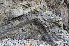
Swallowtree Bay anticline-syncline couplet: detail…
| |
|
|
Saundersfoot to Swallowtree Bay geological structures
Detail view no.7 of the asymmetric anticline-syncline couplet in Lower Coal Measures sandstones and siltstones, just south of Swallowtree Bay.
This photo shows the vertical limb of the fold couplet pair. In the centre, the vertical limb is composed mainly of sandstones with thin darker silty laminae. The sandstone beds show a strong fracture fan cleavage perpendicular to the bedding, especially marked on this vertical limb of the fold. Minor thrust planes disrupt the thinner sandstone beds by a few centimetres. To the left, finer, darker, laminated siltstones show little or no cleavage.
I took this photo for the shapes, textures and colours as well as the geological interest, hence I omitted a scale object. The section shown is about 1 metre in height.
The photo of the entire structure is here:
Swallowtree Bay anticline-syncline couplet: detail…
| |
|
Saundersfoot to Swallowtree Bay geological structures
Detail view no.6 of the asymmetric anticline-syncline couplet in Lower Coal Measures sandstones and siltstones, just south of Swallowtree Bay.
This photo mainly shows the vertical limb of the fold couplet pair. The axis of the anticline is on the left. In the centre, the vertical limb is composed mainly of sandstones with thin darker silty laminae. The sandstone beds show a strong fracture fan cleavage perpendicular to the bedding, especially marked on this vertical limb of the fold.
I took this photo for the shapes, textures and colours as well as the geological interest, hence I omitted a scale object. The section shown is about 2 metres in height.
The photo of the entire structure is here:
Swallowtree Bay anticline-syncline couplet: detail…
| |
|
|
Saundersfoot to Swallowtree Bay geological structures
Detail view no.4 of the asymmetric anticline-syncline couplet in Lower Coal Measures sandstones and siltstones, just south of Swallowtree Bay.
This is a view of the siltstones and sandstones in the fold axis of the anticline below the small thrust which disrupts the fold axis.
The sandstone beds show thickness variation due to channelling and erosive bases into the underlying laminated sandy siltstone beds. Apparent low-angle cross bedding in the central, darker laminated sandy siltstone bed may be partly due to dislocation and bedding plane slip at its junction with the next underlying sandstone.
I took this photo for the shapes, textures and colours as well as the geological interest, hence I omitted a scale object. The section shown is about 1.6 metres in height.
The photo of the entire structure is here:
Swallowtree Bay anticline-syncline couplet: detail…
| |
|
Saundersfoot to Swallowtree Bay geological structures
Detailed portrait format view no.3 of the asymmetric anticline-syncline couplet in Lower Coal Measures sandstones and siltstones, just south of Swallowtree Bay.
This is a view of the siltstones and sandstones in the fold axis of the anticline. The southern (left) limb of the fold shows much crumpling and shearing in the weaker, laminated siltstones.
I took this photo for the shapes, textures and colours as well as the geological interest, hence I omitted a scale object. The section shown is about 1.8 metres in height.
The photo of the entire structure is here:
Swallowtree Bay anticline-syncline couplet: detail…
| |
|
Saundersfoot to Swallowtree Bay geological structures
Detail view no.2 of the asymmetric anticline-syncline couplet in Lower Coal Measures sandstones and siltstones, just south of Swallowtree Bay.
This is a view of the siltstones and sandstones in the fold axis of the anticline. The southern (left) limb of the fold shows much crumpling and shearing in the weaker, laminated siltstones.
The stronger sandstone beds show a strong fracture fan cleavage perpendicular to the bedding, especially marked on the vertical limb of the fold.
I took this photo for the shapes, textures and colours as well as the geological interest, hence I omitted a scale object. The section shown is about 1 metre in height.
The photo of the entire structure is here:
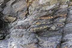
Extentional faults detail: Saundersfoot south
| |
|
Saundersfoot to Swallowtree Bay geological structures
Detail of the faulted Lower Coal Measures rocks in the previous photo. I particularly liked the colours and textures of these rock and did not want to detract from these by including a scale object. The photo is about 1 metre top to bottom. The rocks are mostly grey mudstones with brown ironstone bands and nodules.
The Settlands sand trees 2
| |
|
|
|
I was intrigued by the 'forests' created in the sand by the rivulets of water draining from The Settlands beach near Little Haven, Pembrokeshire.
Fox Hole Anticline - northern limb jointing with c…
| |
|
|
|
Structural geology of Little Haven and The Settlands
The cliffs from Little Haven to Broad Haven (and northward) display a spectacular range of geological structures, folding, faulting and thrusting, mainly in the Lower Coal Measures. The relatively weak mudstone and shale-dominated sequences show much incompetent deformation: tight, thrusted and overturned folds, in contrast to the thicker, stronger, sandstones which have formed relatively open and concentric folds.
The northern limb of the Fox Hole anticline forms the southern headland of The Settlands bay. The style of folding is open and concentric, largely due to the thick (approx 70 m in total) and competent (strong) nature of the sandstone of which it is comprised. At the western end of the headland the bedding dips at about 30° to the north, but this steepens along its length to become near-vertical at the eastern end of the headland.
This is a view looking head-on at the steeply dipping bedding surfaces. The bedding is cut by nurmerous joints (fractures) which in this case has been enlarged by erosion to form a shallow sea cave at beach level. Someone has lit a candle on a rack inside the cave. Perhaps a memorial to a loved one?
Nolton Haven channel lag deposit in beach boulder…
| |
|
Nolton Haven to Newgale
The small Nolton-Newgale coalfield is separated by faulting from the main Pembrokeshire coalfield. It lies mostly within Pennant Sandstone Formation of the Upper Coal Measures rocks.
The cliffs of Nolton Haven expose predominantly deltaic channel sandstones, often with highly erosive bases with coarse, rip-up, channel-lag deposits. The general dip is around 20° to the south-west.
This photo shows a cross-section view of a locally derived beach boulder consisting of a channel lag deposit with ironstone pebbles and fragments set in a pale grey coarse sandstone matrix. The boulder is approx. 50 cm thick.
Nolton Haven channel lag deposit in beach boulder…
| |
|
Nolton Haven to Newgale
The small Nolton-Newgale coalfield is separated by faulting from the main Pembrokeshire coalfield. It lies mostly within Pennant Sandstone Formation of the Upper Coal Measures rocks.
The cliffs of Nolton Haven expose predominantly deltaic channel sandstones, often with highly erosive bases with coarse, rip-up, channel-lag deposits. The general dip is around 20° to the south-west.
This photo shows the uoper surface of a locally derived beach boulder consisting of a channel lag deposit with ironstone pebbles and fragments set in a pale grey coarse sandstone matrix.
Nolton Haven channel sandstones 3
| |
|
Nolton Haven to Newgale
The small Nolton-Newgale coalfield is separated by faulting from the main Pembrokeshire coalfield. It lies mostly within Pennant Sandstone Formation of the Upper Coal Measures rocks.
The cliffs of Nolton Haven expose predominantly deltaic channel sandstones, often with highly erosive bases with coarse, rip-up, channel-lag deposits. The general dip is around 20° to the south-west.
This photo shows planar laminated sandstones with an erosive base resting on the underlying sandstone unit. Planar laminated sandstones in this setting often indicate high energy, fast current flow.
The photo is approx. 60 cm from top to bottom.
Nolton Haven channel sandstones 2
| |
|
Nolton Haven to Newgale
The small Nolton-Newgale coalfield is separated by faulting from the main Pembrokeshire coalfield. It lies mostly within Pennant Sandstone Formation of the Upper Coal Measures rocks.
The cliffs of Nolton Haven expose predominantly deltaic channel sandstones, often with highly erosive bases with coarse, rip-up, channel-lag deposits. The general dip is around 20° to the south-west.
This photo shows planar laminated sandstones with an erosive base (marked by the walking stick handle) cutting into the underlying sandstone unit. Planar laminated sandstones in this setting often indicate high energy, fast current flow.
The walking stick is 90 cm long.
Green Bridge of Wales
| |
|
|
|
Pembrokeshire Coast Path from St Govans to the Green Bridge of Wales
The classic view of the Green Bridge of Wales sea arch, formed in the upper part of the Dinantian age Carboniferous Limestone Series. The small isolated sea stack to the right is probably the remnant pillar of a former sea arch, now collapsed, which joined on to the main arch pillar.
The flat landform topography represents the '200 foot platform' - a Tertiary age marine erosion surface.
Old Man of Stoer 2
| |
|
The Old Man of Stoer is a sea stack of Torridonian Sandstone on the Stoer peninsula, NW Scotland.
The mountains of Harris in the Outer Hebrides are just visible on the sky line at the upper left.
Dùn Caan and shower cloud from Hallaig
| |
|
|
A walk to the abandoned settlement of Hallaig on the island of Raasay
Another great view of Dùn Caan, the highest point on Raasay (444 m), seen from the abandoned settlement of Hallaig. Dùn Cann, like much of eastern Raasay, is composed of Jurassic sedimentary rocks. However, the summit is capped with a basalt lava flow, part of the Palaeocene age Skye Lava Group. The basalt displays excellent columnar cooling joints, nicely picked out by the oblique sunshine.
Bay of Stoer Formation bedding plane
| |
|
Alternating sandstones and softer siltstones/mudstones in the Bay of Stoer Formation (1200 Ma) have eroded differentially to form a series of narrow inlets at Sgèir na Tràghad, near Clachtoll. The photo shows a broad expanse of a single bedding plane of one of the sandstones.
The Coigach peninsula is visible on the skyline.
Sgèir na Tràghad 1
| |
|
Alternating sandstones and softer siltstones/mudstones in the Bay of Stoer Formation (1200 Ma) have eroded differentially to form a series of narrow inlets at Sgèir na Tràghad, near Clachtoll. A small erratic boulder of Lewisian Gneiss rests in the foreground.
The Coigach peninsula is visible on the skyline.
Dùn Caan summit: southern panorama
| |
|
|
A walk to Dùn Caan 13
The summit of Dùn Caan is very fine indeed with spectacular views in all directions. There are many contrasting colours in the rocks, vegetation and peaty soil.
This photo is a panorama from two separate photos stitched together. The view is to the south, with the mountains of Skye in the distance; also the island of Scalpay in centre. The main body of water is the Inner Sound with the Crowlin Islands, Longay and Pabay visible (see notes).
To the east of the summit, the ground falls away steeply in a series of crags and escarpments. The green flat area left of centre marks the abandoned settlement of Hallaig, a victim of the brutal Highland clearances.
I had the summit to myself and spent over an hour here just taking in the scenery.
Jump to top
RSS feed- Latest items - Subscribe to the latest items added to this album
- ipernity © 2007-2024
- Help & Contact
|
Club news
|
About ipernity
|
History |
ipernity Club & Prices |
Guide of good conduct
Donate | Group guidelines | Privacy policy | Terms of use | Statutes | In memoria -
Facebook
Twitter


