


Geological structures

Folder: Geology and Earth Science
Photos illustrating geological structures such as folds, faults, joints, etc.
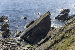
Victoria Bay bedding planes in Silurian sandstones
| |
|
|
|
A view over the small inlet of Victoria Bay near Marloes in Pembrokeshire.
Slabs of Silurian age sandstones dip at about 40° to the south.
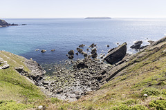
Victoria Bay and Skokholm Island
| |
|
|
|
A view over the small inlet of Victoria Bay near Marloes in Pembrokeshire. Skokholm Island is visible in the distance.
Slabs of Silurian age sandstones dip at about 40° to the south.
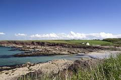
St Brides Haven - view east
| |
|
St Brides Haven in Pembrokeshire shows off her colours! Red sandstones and mudstones of the Devonian age Old Red Sandstone contrast with the turquoise sea on this beautiful summer's day.
The rocks are gently folded into a series of open anticlines and synclines, visible on the far side of the inlet.
The white building is Cliff Cottage (available for holiday let).
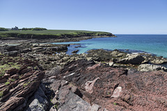
St Brides Haven: colourful rocks, colourful sea
| |
|
|
St Brides Haven in Pembrokeshire shows off her colours! Red sandstones and mudstones of the Devonian age Old Red Sandstone contrast with the turquoise sea on this beautiful summer's day.
The rocks are gently folded into a series of open anticlines and synclines, visible on the far side of the inlet.
The prominent building on the left skyline is St Brides Castle, a 19th-century baronial country mansion.
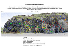
Druidston Haven: Cliff Section 1 interpretation
| |
|
Druidston Haven geology: Cliff Section 1 interpretation
Interpretation No.1 of a series of six photos and interpretations to illustrate the geology of Druidston Haven, Pembrokeshire. Photo No.1 of a series of six photos and interpretations to illustrate the geology of Druidston Haven, Pembrokeshire. The background is a panoramic view of two photos stitched together using Photoshop software.
The cliffs of Druidston Haven mostly consist of Ordovician (Caradocian) age shales with some thin sandstones. During the Caledonian orgogeny at the end of the Silurian period, these were deformed into a series of mostly upright open folds. These were then re-folded by Variscan movements at the end of Carboniferous, to become largely recumbent (near horizontal) or partly inverted, facing down towards the south.
The Ordovician rocks form a horst - a ridge or block of strata faulted against younger rocks on either side. The Druidston Horst is bounded by the South Druidston Boundary Fault at the south end of the Haven, and the North Druidston Boundary Fault at the north end. These photos show the section midway along the horst from the stream to the Southern Boundary Fault at the far end.
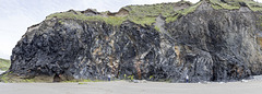
Druidston Haven: Cliff Section 1 panorama
| |
|
Druidston Haven geology: Cliff Section 1
Photo No.1 of a series of six photos and interpretations to illustrate the geology of Druidston Haven, Pembrokeshire. This is a panoramic view of two photos stitched together using Photoshop software.
The cliffs of Druidston Haven mostly consist of Ordovician (Caradocian) age shales with some thin sandstones. During the Caledonian orgogeny at the end of the Silurian period, these were deformed into a series of mostly upright open folds. These were then re-folded by Variscan movements at the end of Carboniferous, to become largely recumbent (near horizontal) or partly inverted, facing down towards the south.
The Ordovician rocks form a horst - a ridge or block of strata faulted against younger rocks on either side. The Druidston Horst is bounded by the South Druidston Boundary Fault at the south end of the Haven, and the North Druidston Boundary Fault at the north end. These photos show the section midway along the horst from the stream to the Southern Boundary Fault at the far end.
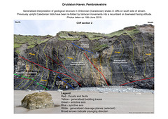
Druidston Haven: Cliff Section 2 interpretation
| |
|
Druidston Haven geology: Cliff Section 2 interpretation
Interpretation No.2 of a series of six photos and interpretations to illustrate the geology of Druidston Haven, Pembrokeshire.
The cliffs of Druidston Haven mostly consist of Ordovician (Caradocian) age shales with some thin sandstones. During the Caledonian orgogeny at the end of the Silurian period, these were deformed into a series of mostly upright open folds. These were then re-folded by Variscan movements at the end of Carboniferous, to become largely recumbent (near horizontal) or partly inverted, facing down towards the south.
The Ordovician rocks form a horst - a ridge or block of strata faulted against younger rocks on either side. The Druidston Horst is bounded by the South Druidston Boundary Fault at the south end of the Haven, and the North Druidston Boundary Fault at the north end. These photos show the section midway along the horst from the stream to the Southern Boundary Fault at the far end.
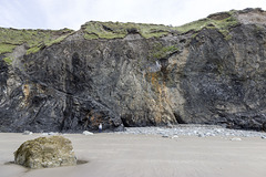
Druidston Haven: Cliff Section 2
| |
|
Druidston Haven geology: Cliff Section 2
Photo No.2 of a series of six photos and interpretations to illustrate the geology of Druidston Haven, Pembrokeshire.
The cliffs of Druidston Haven mostly consist of Ordovician (Caradocian) age shales with some thin sandstones. During the Caledonian orgogeny at the end of the Silurian period, these were deformed into a series of mostly upright open folds. These were then re-folded by Variscan movements at the end of Carboniferous, to become largely recumbent (near horizontal) or partly inverted, facing down towards the south.
The Ordovician rocks form a horst - a ridge or block of strata faulted against younger rocks on either side. The Druidston Horst is bounded by the South Druidston Boundary Fault at the south end of the Haven, and the North Druidston Boundary Fault at the north end. These photos show the section midway along the horst from the stream to the Southern Boundary Fault at the far end.
Druidston Haven: Cliff Section 3 interpretation
| |
|
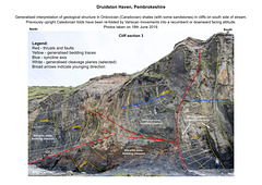
Druidston Haven geology: Cliff Section 3 interpretation
Interpretation No.3 of a series of six photos and interpretations to illustrate the geology of Druidston Haven, Pembrokeshire.
The cliffs of Druidston Haven mostly consist of Ordovician (Caradocian) age shales with some thin sandstones. During the Caledonian orgogeny at the end of the Silurian period, these were deformed into a series of mostly upright open folds. These were then re-folded by Variscan movements at the end of Carboniferous, to become largely recumbent (near horizontal) or partly inverted, facing down towards the south. The sandstone beds seen in this photo show irregular slumped bases and load casts, thus confirming that these beds young to the south (right).
The Ordovician rocks form a horst - a ridge or block of strata faulted against younger rocks on either side. The Druidston Horst is bounded by the South Druidston Boundary Fault at the south end of the Haven, and the North Druidston Boundary Fault at the north end. These photos show the section midway along the horst from the stream to the Southern Boundary Fault at the far end.
Druidston Haven: Cliff Section 3
| |
|
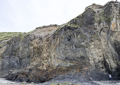
Druidston Haven geology: Cliff Section 3
Photo No.3 of a series of six photos and interpretations to illustrate the geology of Druidston Haven, Pembrokeshire.
The cliffs of Druidston Haven mostly consist of Ordovician (Caradocian) age shales with some thin sandstones. During the Caledonian orgogeny at the end of the Silurian period, these were deformed into a series of mostly upright open folds. These were then re-folded by Variscan movements at the end of Carboniferous, to become largely recumbent (near horizontal) or partly inverted, facing down towards the south. The sandstone beds seen in this photo show irregular slumped bases and load casts, thus confirming that these beds young to the south (right).
The Ordovician rocks form a horst - a ridge or block of strata faulted against younger rocks on either side. The Druidston Horst is bounded by the South Druidston Boundary Fault at the south end of the Haven, and the North Druidston Boundary Fault at the north end. These photos show the section midway along the horst from the stream to the Southern Boundary Fault at the far end.
Druidston Haven: Cliff Section 4 interpretation
| |
|
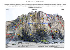
Druidston Haven geology: Cliff Section 4 interpretation
Interpretation No.4 of a series of six photos and interpretations to illustrate the geology of Druidston Haven, Pembrokeshire.
The cliffs of Druidston Haven mostly consist of Ordovician (Caradocian) age shales with some thin sandstones. During the Caledonian orgogeny at the end of the Silurian period, these were deformed into a series of mostly upright open folds. These were then re-folded by Variscan movements at the end of Carboniferous, to become largely recumbent (near horizontal) or partly inverted, facing down towards the south. The sandstone beds seen in this photo show irregular slumped bases and load casts, thus confirming that these beds young to the south (right).
The Ordovician rocks form a horst - a ridge or block of strata faulted against younger rocks on either side. The Druidston Horst is bounded by the South Druidston Boundary Fault at the south end of the Haven, and the North Druidston Boundary Fault at the north end. These photos show the section midway along the horst from the stream to the Southern Boundary Fault at the far end.
Druidston Haven: Cliff Section 4
| |
|
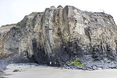
Druidston Haven geology: Cliff Section 4
Photo No.4 of a series of six photos and interpretations to illustrate the geology of Druidston Haven, Pembrokeshire.
The cliffs of Druidston Haven mostly consist of Ordovician (Caradocian) age shales with some thin sandstones. During the Caledonian orgogeny at the end of the Silurian period, these were deformed into a series of mostly upright open folds. These were then re-folded by Variscan movements at the end of Carboniferous, to become largely recumbent (near horizontal) or partly inverted, facing down towards the south. The sandstone beds seen in this photo show irregular slumped bases and load casts, thus confirming that these beds young to the south (right).
The Ordovician rocks form a horst - a ridge or block of strata faulted against younger rocks on either side. The Druidston Horst is bounded by the South Druidston Boundary Fault at the south end of the Haven, and the North Druidston Boundary Fault at the north end. These photos show the section midway along the horst from the stream to the Southern Boundary Fault at the far end.
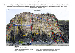
Druidston Haven: Cliff Section 5 interpretation
| |
|
Druidston Haven geology: Cliff Section 5 interpretation
Interpretation No.5 of a series of six photos and interpretations to illustrate the geology of Druidston Haven, Pembrokeshire.
The cliffs of Druidston Haven mostly consist of Ordovician (Caradocian) age shales with some thin sandstones. During the Caledonian orgogeny at the end of the Silurian period, these were deformed into a series of mostly upright open folds. These were then re-folded by Variscan movements at the end of Carboniferous, to become largely recumbent (near horizontal) or partly inverted, facing down towards the south.
The Ordovician rocks form a horst - a ridge or block of strata faulted against younger rocks on either side. The Druidston Horst is bounded by the South Druidston Boundary Fault at the south end of the Haven, and the North Druidston Boundary Fault at the north end. These photos show the section midway along the horst from the stream to the Southern Boundary Fault at the far end.
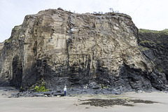
Druidston Haven: Cliff Section 5
| |
|
Druidston Haven geology: Cliff Section 5
Photo No.5 of a series of six photos and interpretations to illustrate the geology of Druidston Haven, Pembrokeshire.
The cliffs of Druidston Haven mostly consist of Ordovician (Caradocian) age shales with some thin sandstones. During the Caledonian orgogeny at the end of the Silurian period, these were deformed into a series of mostly upright open folds. These were then re-folded by Variscan movements at the end of Carboniferous, to become largely recumbent (near horizontal) or partly inverted, facing down towards the south.
The Ordovician rocks form a horst - a ridge or block of strata faulted against younger rocks on either side. The Druidston Horst is bounded by the South Druidston Boundary Fault at the south end of the Haven, and the North Druidston Boundary Fault at the north end. These photos show the section midway along the horst from the stream to the Southern Boundary Fault at the far end.
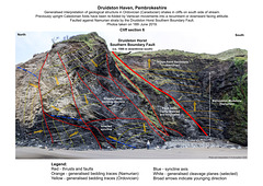
Druidston Haven: Cliff Section 6 interpretation
| |
|
Druidston Haven geology: Cliff Section 6 interpretation
Interpretation No.6 of a series of six photos and interpretations to illustrate the geology of Druidston Haven, Pembrokeshire.
The cliffs of Druidston Haven mostly consist of Ordovician (Caradocian) age shales with some thin sandstones. During the Caledonian orgogeny at the end of the Silurian period, these were deformed into a series of mostly upright open folds. These were then re-folded by Variscan movements at the end of Carboniferous, to become largely recumbent (near horizontal) or partly inverted, facing down towards the south.
The Ordovician rocks form a horst - a ridge or block of strata faulted against younger rocks on either side. The Druidston Horst is bounded by the South Druidston Boundary Fault at the south end of the Haven, and the North Druidston Boundary Fault at the north end. This photo shows the southern end of the horst, terminated by the Southern Boundary Fault; a significant structure with a throw (displacement) of at least 1500 metres to the south, bringing Namurian 'Millstone Grit Series' (upper Carboniferous) rocks into contact with the Ordovician shales.
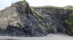
Druidston Haven: Cliff Section 6
| |
|
Druidston Haven geology: Cliff Section 6
Photo No.6 of a series of six photos and interpretations to illustrate the geology of Druidston Haven, Pembrokeshire.
The cliffs of Druidston Haven mostly consist of Ordovician (Caradocian) age shales with some thin sandstones. During the Caledonian orgogeny at the end of the Silurian period, these were deformed into a series of mostly upright open folds. These were then re-folded by Variscan movements at the end of Carboniferous, to become largely recumbent (near horizontal) or partly inverted, facing down towards the south.
The Ordovician rocks form a horst - a ridge or block of strata faulted against younger rocks on either side. The Druidston Horst is bounded by the South Druidston Boundary Fault at the south end of the Haven, and the North Druidston Boundary Fault at the north end. This photo shows the southern end of the horst, terminated by the Southern Boundary Fault; a significant structure with a throw (displacement) of at least 1500 metres to the south, bringing Namurian 'Millstone Grit Series' (upper Carboniferous) rocks into contact with the Ordovician shales.
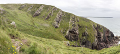
East Pickard Bay panorama
| |
|
|
|
Freshwater West, Gravel Bay and East Pickard Bay
Moor Cliffs Formation at East Pickard Bay.
This photo was taken from coastal path and shows a general view of the upper part of the Moor Cliffs Formation at East Pickard Bay. The prominent ribs mark a series of tuffs (volcanic ash fall deposits) which can be used as stratigraphic markers. The sequence is dipping to the north (left) at approx. 50° - 65°. The headland of Linney Head is on the skyline in the right distance.
Panoramic view comprised of three landscape photos stitched together using Photoshop software.
Background:
The Moor Cliffs Formation overlies the Freshwater East conglomerates, seen in previous photos, and spans the boundary between the Silurian and Devonian periods. It consists of red mudstones and siltstones with occasional thin sandstone beds. These were deposited on a low-reflief floodplain at the edge of an arid continental margin, the sandstones being deposited by seasonal braided streams, the muds and silts deposited in ephemeral marginal lakes. When not inundated, the muds and silts developed carbonate-rich calcrete (caliche) soil horizons along dessication cracks, burrows and early plant root systems.
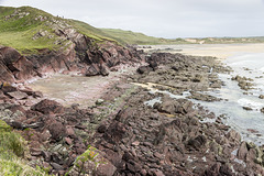
Gravel Bay - Moor Cliffs Formation
| |
|
|
Freshwater West, Gravel Bay and East Pickard Bay
Moor Cliffs Formation in Gravel Bay.
This photo was taken from coastal path and shows an easterly view of the wave cut platform in the Moor Cliffs Formation at the western end of Gravel Bay. Thin sandstone beds show up as greenish or purplish grey. The sequence is dipping to the north (left) at approx. 60° - 65°. The Blown Sand dunes of Broomhill Burrows are visible in the upper right.
Background:
The Moor Cliffs Formation overlies the Freshwater East conglomerates, seen in previous photos, and spans the boundary between the Silurian and Devonian periods. It consists of red mudstones and siltstones with occasional thin sandstone beds. These were deposited on a low-reflief floodplain at the edge of an arid continental margin, the sandstones being deposited by seasonal braided streams, the muds and silts deposited in ephemeral marginal lakes. When not inundated, the muds and silts developed carbonate-rich calcrete (caliche) soil horizons along dessication cracks, burrows and early plant root systems.
Jump to top
RSS feed- Latest items - Subscribe to the latest items added to this album
- ipernity © 2007-2026
- Help & Contact
|
Club news
|
About ipernity
|
History |
ipernity Club & Prices |
Guide of good conduct
Donate | Group guidelines | Privacy policy | Terms of use | Statutes | In memoria -
Facebook
X
