

Earthwatcher's photos
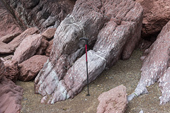
Gravel Bay - Moor Cliffs Formation with calcretes…
| |
|
|
Freshwater West, Gravel Bay and East Pickard Bay
Moor Cliffs Formation in Gravel Bay.
This photo shows a closer view of the mainly reddened mudstone beds in the Moor Cliffs Formation at the western end of Gravel Bay. The white mottling in the mudstones shows extensive calcrete soil horizons. The sequence is dipping to the north (right) at approx. 65°.
The walking stick is about 0.9 m long.
Background:
The Moor Cliffs Formation overlies the Freshwater East conglomerates, seen in previous photos, and spans the boundary between the Silurian and Devonian periods. It consists of red mudstones and siltstones with occasional thin sandstone beds. These were deposited on a low-reflief floodplain at the edge of an arid continental margin, the sandstones being deposited by seasonal braided streams, the muds and silts deposited in ephemeral marginal lakes. When not inundated, the muds and silts developed carbonate-rich calcrete (caliche) soil horizons along dessication cracks, burrows and early plant root systems.
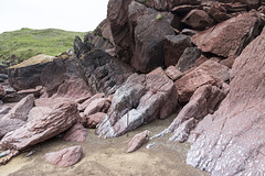
Gravel Bay - Moor Cliffs Formation with calcretes…
| |
|
Freshwater West, Gravel Bay and East Pickard Bay
Moor Cliffs Formation in Gravel Bay.
This photo shows the mainly reddened mudstone beds in the Moor Cliffs Formation at the western end of Gravel Bay. The white mottling in the mudstones shows extensive calcrete soil horizons. The sequence is dipping to the north (right) at approx. 65°.
The walking stick is about 0.9 m long.
Background:
The Moor Cliffs Formation overlies the Freshwater East conglomerates, seen in previous photos, and spans the boundary between the Silurian and Devonian periods. It consists of red mudstones and siltstones with occasional thin sandstone beds. These were deposited on a low-reflief floodplain at the edge of an arid continental margin, the sandstones being deposited by seasonal braided streams, the muds and silts deposited in ephemeral marginal lakes. When not inundated, the muds and silts developed carbonate-rich calcrete (caliche) soil horizons along dessication cracks, burrows and early plant root systems.
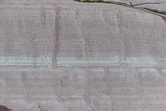
Gravel Bay - millipede-like burrows in Moor Cliffs…
| |
|
|
Freshwater West, Gravel Bay and East Pickard Bay
Moor Cliffs Formation in Gravel Bay.
This photo shows a close-up view of the light purple sandstone bed with greenish laminae seen in the previous photo. The darker perpendicular features in the sandstone are trace-fossil Beaconites burrows. Having previously been tentatively ascribed to worm burrows or lung-fish burrows, they are now thought to have been made by primitive millipede-like animals.
The bed is approx. 50 cm thick (top to bottom) in this photo.
Background:
The Moor Cliffs Formation overlies the Freshwater East conglomerates, seen in previous photos, and spans the boundary between the Silurian and Devonian periods. It consists of red mudstones and siltstones with occasional thin sandstone beds. These were deposited on a low-reflief floodplain at the edge of an arid continental margin, the sandstones being deposited by seasonal braided streams, the muds and silts deposited in ephemeral marginal lakes. When not inundated, the muds and silts developed carbonate-rich calcrete (caliche) soil horizons along dessication cracks, burrows and early plant root systems.
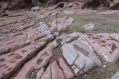
Gravel Bay - Moor Cliffs Formation 2
| |
|
|
Freshwater West, Gravel Bay and East Pickard Bay
Moor Cliffs Formation in Gravel Bay.
This photo shows a closer view of the wave cut platform in the Moor Cliffs Formation at the western end of Gravel Bay. A light purple sandstone bed with greenish laminae is seen in the centre of the photo with red mudstones below (left) and above (right). The darker perpendicular features in the sandstone are trace-fossil Beaconites burrows. Having previously been tentatively ascribed to worm burrows or lung-fish burrows, they are now thought to have been made by primitive millipede-like animals.
The white mottling in the mudstones indicate extensive calcrete soil horizons. The sequence is dipping to the north (right) at approx. 60°.
The walking stick is about 0.9 m long.
Background:
The Moor Cliffs Formation overlies the Freshwater East conglomerates, seen in previous photos, and spans the boundary between the Silurian and Devonian periods. It consists of red mudstones and siltstones with occasional thin sandstone beds. These were deposited on a low-reflief floodplain at the edge of an arid continental margin, the sandstones being deposited by seasonal braided streams, the muds and silts deposited in ephemeral marginal lakes. When not inundated, the muds and silts developed carbonate-rich calcrete (caliche) soil horizons along dessication cracks, burrows and early plant root systems.
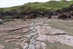
Gravel Bay - Moor Cliffs Formation 1
| |
|
Freshwater West, Gravel Bay and East Pickard Bay
Moor Cliffs Formation in Gravel Bay.
This photo shows the wave cut platform in the Moor Cliffs Formation at the western end of Gravel Bay. A light purple sandstone bed is seen in the centre of the photo with red mudstones below (left) and above (right). The white mottling towards the right is a particularly well-developed calcrete horizon. The sequence is dipping to the north (right) at approx. 60°.
The walking stick is about 0.9 m long.
Background:
The Moor Cliffs Formation overlies the Freshwater East conglomerates, seen in previous photos, and spans the boundary between the Silurian and Devonian periods. It consists of red mudstones and siltstones with occasional thin sandstone beds. These were deposited on a low-reflief floodplain at the edge of an arid continental margin, the sandstones being deposited by seasonal braided streams, the muds and silts deposited in ephemeral marginal lakes. When not inundated, the muds and silts developed carbonate-rich calcrete (caliche) soil horizons along dessication cracks, burrows and early plant root systems.

Freshwater West walkies
| |
|
|
Freshwater West, Gravel Bay and East Pickard Bay
It was rather a dull morning, with a moody sky over the broad sweep of Freshwater West in south Pembrokeshire, viewed from Gravel Bay. This couple and their dog came along at just the right moment.

Spray haze over Freshwater West
| |
|
|
Freshwater West, Gravel Bay and East Pickard Bay
It was rather a dull morning, with a moody sky over the beach at low tide. This is looking south from Gravel Bay at the northern end of the broad sweep of Freshwater West in south Pembrokeshire. A beach-hugging haze of spray adds to the minimalist softness of the scene.

Moody sky over Freshwater West
| |
|
|
|
Freshwater West, Gravel Bay and East Pickard Bay
Although it was a dull morning, with a moody sky over the beach at low tide, I rather liked this minimalist shoreline view. This is looking south from Gravel Bay at the northern end of the broad sweep of Freshwater West in south Pembrokeshire.
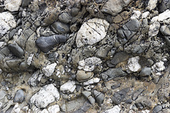
Conglomerate at Gravel Bay: close-up view 2
| |
|
|
Freshwater West, Gravel Bay and East Pickard Bay
Another close-up view of a conglomerate in the Freshwater East Formation (note name) at Gravel Bay, situated at the northern end of the large Freshwater West bay in south Pembrokeshire. The view is closely adjacent to the previous photo but without the lens cap for scale, as I didn't want it to distract from the lovely textures in this rock.
The vertical dimension of the photo is about 40 cm.
The Freshwater East Formation marks the beginning of 'Old Red Sandstone' type of sediments, formerly believed to be at the base of the Devonian, but now assigned to the uppermost Silurian. The pebbles and cobbles in the conglomerates mostly consist of white vein quartz and quartzite, grey sandstones and darker sitstones. These were depositied in an alluvial fan settting on a shallow floodplain in increasingly arid conditions.
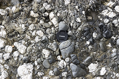
Conglomerate at Gravel Bay: close-up view 1
| |
|
Freshwater West, Gravel Bay and East Pickard Bay
Close-up view of a conglomerate in the Freshwater East Formation (note name) at Gravel Bay, situated at the northern end of the large Freshwater West bay in south Pembrokeshire. The lens cap is 72 mm in diameter.
The Freshwater East Formation marks the beginning of 'Old Red Sandstone' type of sediments, formerly believed to be at the base of the Devonian, but now assigned to the uppermost Silurian. The pebbles and cobbles in the conglomerates mostly consist of white vein quartz and quartzite, grey sandstones and darker sitstones. These were depositied in an alluvial fan settting on a shallow floodplain in increasingly arid conditions.
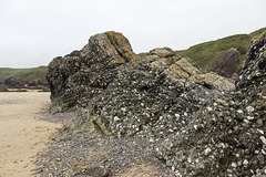
Conglomerates at Gravel Bay
| |
|
|
|
Freshwater West, Gravel Bay and East Pickard Bay
Massive conglomerates and grey sandstones dipping steeply to the north (right) of the Freshwater East Formation (note name) at Gravel Bay, situated at the northern end of the large Freshwater West bay in south Pembrokeshire. The walking stick is 0.9 m long.
The Freshwater East Formation marks the beginning of 'Old Red Sandstone' type of sediments, formerly believed to be at the base of the Devonian, but now assigned to the uppermost Silurian. The pebbles and cobbles in the conglomerates mostly consist of white vein quartz and quartzite, grey sandstones and darker sitstones. These were depositied in an alluvial fan settting on a shallow floodplain in increasingly arid conditions.

Raasay: Churchton Bay, Ferry, and Ben Tianavaig on…
| |
|
A view of Churchton Bay at Clachan on Raasay, taken from the old ironstone mine tramway. The ferry is just departing from the terminal bound for Sconser.
Ben Tianavaig on Skye forms an impressive backdrop.

Raasay: Churchton Bay and Ben Tianavaig on Skye
| |
|
A view of Churchton Bay at Clachan on Raasay, taken from the old ironstone mine tramway. The long sunlit building to the right of centre of the photo is the modern Inverarish Community Centre.
Ben Tianavaig on Skye forms an impressive backdrop.

Raasay: Inverarish from mine tramway
| |
|
A view of Inverarish and Churchton Bay taken from the old ironstone mine tramway. The buildings in the foreground are Inverarish Terrace, built by William Baird & Co. to house the mine workers, many of whom were German prisoners of war. The long sunlit building in the centre of the photo is the modern Inverarish Community Centre.
The distant hills are on Skye.

Raasay: No.1 Ironstone Mine adit entrance (intake)…
| |
|
|
|
Raasay Ironstone Mine and Processing Works
A photo taken through the steel grille across the intake adit entrance of the Raasay No.1 Ironstone Mine, taken in April 2019. The concrete block walls extend just a short distance in, thereafter it is natural stone with few supports. There were two entrances for the No.1 Mine; this one allowed fresh air into the mine and was the main haulage road for ore. The link below shows the mine entrance in 1917.
The other adit for return (exhaust) air and its ventilation fan was located a short distance away.
Background
The two adits of Raasay No.1 ironstone Mine were situated about 2.5 km north of East Suisnish pier and worked the Jurassic (Upper Lias) age siderite and chamosite ores from 1914 to 1920. The mine was owned and developed by William Baird & Co. who also built the terraces of houses in the village of Inverarish to house the mine workers, many of whom were German prisoners of war. A tramway and incline connected the mine to the processing works (crusher, calcining kilns, gantries, loading hoppers) at East Suisnish.
A second pair of mine adits (Raasay No.2 Ironstone Mine) just north of Inverarish were also opened up around the same time but never went into proper production due to geological difficulties (faulting).
There was also a small amount of opencast outcrop mining carried out near the No.1 Mine, again around the same time.
The works were dismantled by 1943 but the site is now a scheduled protected monument.
A view of the No.1 Mine in 1917 is here:
geoscenic.bgs.ac.uk/asset-bank/action/viewAsset?id=1338

Raasay: No.1 Ironstone Mine adit entrance (intake)…
| |
|
|
Raasay Ironstone Mine and Processing Works
A closer view of the intake adit entrance of the Raasay No.1 Ironstone Mine, taken in April 2019. There were two entrances for the No.1 Mine; this one allowed fresh air into the mine and was the main haulage road for ore. The link below shows the mine entrance in 1917.
The other adit for return (exhaust) air and its ventilation fan was located a short distance away.
Background
The two adits of Raasay No.1 ironstone Mine were situated about 2.5 km north of East Suisnish pier and worked the Jurassic (Upper Lias) age siderite and chamosite ores from 1914 to 1920. The mine was owned and developed by William Baird & Co. who also built the terraces of houses in the village of Inverarish to house the mine workers, many of whom were German prisoners of war. A tramway and incline connected the mine to the processing works (crusher, calcining kilns, gantries, loading hoppers) at East Suisnish.
A second pair of mine adits (Raasay No.2 Ironstone Mine) just north of Inverarish were also opened up around the same time but never went into proper production due to geological difficulties (faulting).
There was also a small amount of opencast outcrop mining carried out near the No.1 Mine, again around the same time.
The works were dismantled by 1943 but the site is now a scheduled protected monument.
A view of the No.1 Mine in 1917 is here:
geoscenic.bgs.ac.uk/asset-bank/action/viewAsset?id=1338

Raasay: No.1 Ironstone Mine adit entrance (intake)…
| |
|
|
Raasay Ironstone Mine and Processing Works
This is the intake adit entrance of the Raasay No.1 Ironstone Mine, taken in April 2019. There were two entrances for the No.1 Mine; this one allowed fresh air into the mine and was the main haulage road for ore. The link below shows the mine entrance in 1917.
The other adit for return (exhaust) air and its ventilation fan was located a short distance away.
Background
The two adits of Raasay No.1 ironstone Mine were situated about 2.5 km north of East Suisnish pier and worked the Jurassic (Upper Lias) age siderite and chamosite ores from 1914 to 1920. The mine was owned and developed by William Baird & Co. who also built the terraces of houses in the village of Inverarish to house the mine workers, many of whom were German prisoners of war. A tramway and incline connected the mine to the processing works (crusher, calcining kilns, gantries, loading hoppers) at East Suisnish.
A second pair of mine adits (Raasay No.2 Ironstone Mine) just north of Inverarish were also opened up around the same time but never went into proper production due to geological difficulties (faulting).
There was also a small amount of opencast outcrop mining carried out near the No.1 Mine, again around the same time.
The works were dismantled by 1943 but the site is now a scheduled protected monument.
A view of the No.1 Mine in 1917 is here:
geoscenic.bgs.ac.uk/asset-bank/action/viewAsset?id=1338

Raasay: No.1 Ironstone Mine tramway with silver bi…
| |
|
|
Raasay Ironstone Mine and Processing Works
Just north of the viaduct in the previous photos, the No.1 Mine tramway is now overgrown with an attractive double lining of silver birch trees.
Background
The two adits of Raasay No.1 ironstone Mine were situated about 2.5 km north of East Suisnish pier and worked the Jurassic (Upper Lias) age siderite and chamosite ores from 1914 to 1920. The mine was owned and developed by William Baird & Co. who also built the terraces of houses in the village of Inverarish to house the mine workers, many of whom were German prisoners of war. A tramway and incline connected the mine to the processing works (crusher, calcining kilns, gantries, loading hoppers) at East Suisnish.
A second pair of mine adits (Raasay No.2 Ironstone Mine) just north of Inverarish were also opened up around the same time but never went into proper production due to geological difficulties (faulting).
There was also a small amount of opencast outcrop mining carried out near the No.1 Mine, again around the same time.
The works were dismantled by 1943 but the site is now a scheduled protected monument.
A view of the works in 1917 is here:
geoscenic.bgs.ac.uk/asset-bank/action/viewAsset?id=1343
