


Stitched Panoramas

Panoramas stitched from 2 or more photos using MS ICE

Russell Glacier
| |
|
|
|
Russell glacier is an outlet glacier of the Greenlandic ice sheet. It is 25km from Kangerlussuaq and can be reached via Greenland's longest road. This is an increasingly rough gravel road that is ca 40km long from fjord to ice sheet. The first part was built by the American military when they ran the airport at Kangerlussuaq (now Greenland's only international airport), the second part by VW because they wanted to test their cars on the ice. They did this for 10 years until they thought the enterprise too expensive.
Der Russell Gletscher ist ein Auslassgletscher vom grönländischen Inlandseis. Er ist 25 km von Kangerlussuaq entfernt und kann über Grönlands längste Strasse erreicht werden. Dabei handelt es sich um eine im Verlauf zunehmend schlechtere Schotterpiste, die vom Fjord bis zum Eis ca. 40km lang ist. Der erste Teil wurde vom amerikanischen Militär gebaut, als sie noch den Flughafen Kangerlussuaq betrieben, der heute Grönlands einziger internationaler Flughafen ist. Den Rest der Piste baute VW, weil sie ihre Wagen auf dem Inlandseis testen wollten. Das Vergnügen wurde ihnen allerdings nach 10 Jahren zu teuer und sie zogen sich zurück.
Panorama stitched from 22 verticals,
EXIF: 1/160 • f/11.0 • 32.0 mm • ISO 125, Canon EOS 6D, EF24-70mm f/4L IS USM
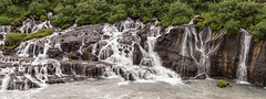
Hraunfossar
| |
|
|
|
Hraunfossar (isl.hraun=lava) are falls streaming out of porous layers of Hallmundarhraun lava field and into Hvitá river.
Hallmundarhraun covers 200 km² and was erupted around 900 A.D. from Langjökull central volcano which is in an active rift zone (western volcanic zone).
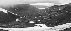
Hrafnseyrarheiði
| |
|
|
|
View from the pass over Hrafnseyrarheiði back to Arnarfjörður. This is one of the highest road passes (552m) in Iceland which is usually impassable in winter. The new road (still unsurfaced) is an improvement on the dangerous old road which can be seen in the middle of the photo.
A new tunnel (Dýrafjarðargöng) was opened in 2010, saving 27km and avoiding the difficult pass.
EXIF:
1/400 • f/8.0 • 24.0 mm • ISO 250, Canon EOS 6D, EF24-105mm f/4L IS USM (stitched from 2 photos)
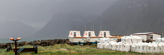
Flateyri harbour
| |
|
|
|
Flateyri is a fishing village in Önundarfjörður, Vestfirðir. The village (like many in the West Fjords) was hit hard by the decline of the fishing industry and the ensuing depopulation. In 1995 an avalanche destroyed 29 houses and killed 20 people.
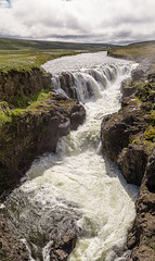
Kolufossar
| |
|
|
|
River Víðidalsá flows through 40-50m deep Kolugljúfur canyon. Folklore has it that a female troll called Kola dug the gorge.
Gullfoss
| |
|
|
|
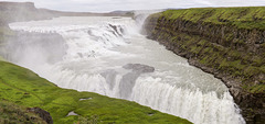
At Gullfoss the river Hvítá descends from the highlands. The river has eroded away the sedimentary layers whereas the interspersed lava flows have withstood better and form the steps over which the water falls.
Hvítágljúfur gorge
I have replaced the panorama with a new version where I have closed a few "holes" by cloning.
Made from 16 vertical shots in two rows. Canon EOS 6D, 24-105/4,0: F/8, 1/200, ISO 125
Gigjökull
| |
|
|
|
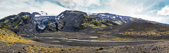
Panorama stitched from 10 verticals. EXIF: Canon EOS 6D, EF24-70mm f/4L IS USM- 55mm, ISO 400, F13, 1/320
Gigjökull (Crater Glacier) comes down from the top of Eyjafjalljökull and can be seen from the F-road to Þórsmörk. The photos were taken from the end moraine.
Before the notorious 2010 eruption this was a famous beauty spot with pristine blue-white ice and a glacier lagoon with icebergs swimming in it. After the eruption the lagoon had disappeared, in its place were ash and volcanic debris and the glacier was a black stump. 12 years later it has started to recuperate though there's still plenty of ash.
www.katlageopark.com/geosites/eyjafjallajokull-gigjokull-steinsholtsjokull
The hidden waterfall
| |
|
|
|
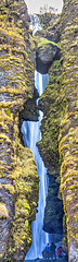
Gljúfrabúi, the hidden waterfall, is just a short walk from better known Seljalandsfoss. Lying under Eyjafjallajökull volcano, it is 40m high and mostly hidden by palagonite rocks in front of it. Getting a nearer view involves scrambling up the rocks or wading the river, both can be hazardous.
Vertical panorama stitched from 6 photos.Inset a detail and the falls seen from a distance.
www.katlageopark.com/geosites/seljalandsfoss-gljufrabui
stuckiniceland.com/south-iceland/the-hidden-beauty-of-gljufrabui
Gljúfrabúi, der vesteckte Wasserfall, ist einen kurzen Spaziergang vom bekannteren Seljalandsfoss entfernt. Er ist 40 m hoch, liegt unterhalb des Eylafjallajökull und ist weitestgehend von Palagonitfelsen verdeckt. Näher heran kommt man nur, wenn man entweder den Felsen hochklettert oder den Fluss durchwatet, beides nicht ganz ungefährlich.
Vertikalpano aus 6 Aufnahmen, im PiP ein Detail und eine Gesamtaufnahme aus der Entfernung.
Rural Iceland
| |
|
|
|
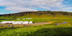
Stitched from 2 photos. EXIF: 1/200 • f/5.6 • 28.0 mm • ISO 100, LEICA CAMERA AG LEICA Q2, SUMMILUX 1:1.7/28 ASPH.
hFF everybody!
Detail of the former coastline at Geirland (photo from 2014)
Skaftafell rainbow
| |
|
|
|
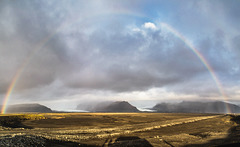
Rainbow over Skaftafellsjökull and Svinafellsjökull, two outlet glaciers from Vatnajökull. The dirt road leads to the construction site for a new bridge over Skeiðará (see inset photo)
Regenbogen über Skaftafellsjökull und Svinafellsjökull, zwei Gletscherzungen des Vatnajökull. Die Schotterstrasse führt zur Baustelle für eine neue Brücke über den Fluss Skeiðará (s.PiP).
Stitched from 2 photos
EXIF: 1/125 • f/13.0 • 24.0 mm • ISO 250/ Canon EOS 6D/ EF24-105mm f/4L IS USM
Svínafellsjökull
| |
|
|
|
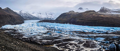
An outlet glacier of Vatnajökull, Svinafellsjökull comes down from Iceland's highest mountain Hvannadalshnúkur (2110m) which sits on the caldera rim of Öræfajökull volcano.
As the glacier retreats the mountainsides have become unstable. There have been major landslides and the popular excursions on the glacier have become dangerous. In 2007 two German mountaineers disapperared without trace.
www.vatnajokulsthjodgardur.is/en/melting-glaciers/vatnajokullglacier
just-iceland.com/de/vatnajokull-svinafellsjokull
Stitched from 2 photos
EXIF: 1/125 • f/8.0 • 28.0 mm • ISO 100 • LEICA CAMERA AG LEICA Q2 • SUMMILUX 1:1.7/28 ASPH.

Fjallsárlón and Fjallsjökull
| |
|
|
|
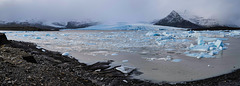
Fjallsjökull like other glaciers has receded, creating a glacier lagoon with icebergs calving into it. On the right is Breiðamerkurjökull, both glaciers are part of Vatnajökull.
Fjallsárlón
| |
|
|
|
Fjallsárlón is a glacial lagoon at the end of Fjallsjökull, an outlet glacier of Vatnajökull
Stitched from 2 photos
EXIF: Leica Q2, 28mm, F/11, 1/200, ISO 100

Jökulsárlón Panorama
| |
|
|
|
Stitched from 13 photos
EXIF: 1/250 • f/10.0 • 98.0 mm • ISO 100/ Canon EOS 6D/ EF24-105mm f/4L IS USM
See full size: www.ipernity.com/doc/523247/44127322/sizes/o
Jökulsárlón glacier lagoon
| |
|
|
|
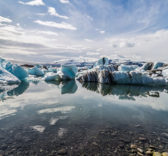
Jökulsárlón, fed by Breiðamerkurjökull glacier, is famous for its floatings icebergs. It is a popular film setting- for a James Bond movie the short river leading to the sea was blocked so the lake could freeze over.
Húsavík
| |
|
|
|
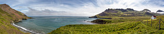
Húsavík was left by its last permanent inhabitants in 1972. Today it consists of 2 houses and a barn. The cemetery has two crosses left, the other graves have been lost to the sea due to erosion. The tiny church is maintained in pristine condition.
Húsavík wurde 1972 von den letzten ständigen Bewohnern verlassen. 2 Häuser sind noch übrig, außerdem eine Scheune und 2 Grabkreuze auf dem Friedhof. Der Rest der Gräber ist durch Erosion ins Meer gerutscht. Die winzige Kirche wird in gepflegtem Zustand erhalten.
Panorama stitched from 15 verticals, EXIF:
1/320 • f/14.0 • 41.0 mm • ISO 100, Canon EOS 6D, EF24-70mm f/4L IS USM
Rauðitindur
Álftavíkurtindur
Bjorg Mattíasdottir, 1836-1879
Fjarðarheiði
| |
|
|
|
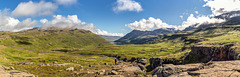
The pass over Fjarðarheiði connects the ferry port of Seyðisfjörður with Egilsstaðir on the Ring Road. As the pass (620m) is often impassable in winter( and even spring) there are plans to build a tunnel. The panorama was taken from the viewpoint halfway up the pass and shows Seyðisfjörður (650 inhabitants) in the distance- see notes.
Der Pass über Fjarðarheiði verbindet den Fährhafen Seyðisfjörður mit Egilsstaðir an der Ringstrasse. Weil die Strasse (Passhöhe 620m) im WInter und selbst im Frühling öfter unpassierbar ist, ist ein Tunnel geplant. Das Panorama ist vom Aussichtspunkt in halber Höhe aufgenommen, Seyðisfjörður ist in der Ferne zu sehen (s. PiPs).
Panorama stitched from 14 verticals
EXIF: 1/200 • f/10.0 • 35.0 mm • ISO 100, Canon EOS 6D, EF24-70mm f/4L IS USM

Möðrudalsöræfi Panorama
| |
|
|
|
View from the pass over Möðrudalsfjallgarður. What is now road 901 used to be part of the ring road until 2005. Möðrudalsöræfi consists of dolerite and palagonite bedrock with cones and ridges from late ice age fissure eruptions.
Large size:
www.ipernity.com/doc/523247/35794459/sizes/o
Jump to top
RSS feed- Latest items - Subscribe to the latest items added to this album
- ipernity © 2007-2026
- Help & Contact
|
Club news
|
About ipernity
|
History |
ipernity Club & Prices |
Guide of good conduct
Donate | Group guidelines | Privacy policy | Terms of use | Statutes | In memoria -
Facebook
X
