USA holiday 1981
15 Feb 2007
Frank Slide, Crowsnest Pass
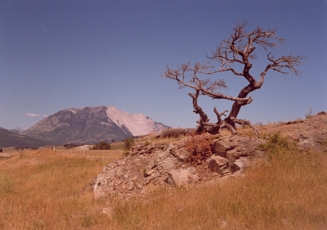
This is a lone tree in the Crowsnest Pass, Alberta. In the distance, you can see the Frank Slide. Scanned from an old photo I took in August 1981.
"On April 29, 1903, at 4:10 a.m., 82 million tonnes (30 million cubic metres) of limestone crashed from the summit of Turtle Mountain and buried a portion of the sleeping town of Frank. The dimensions of the rock mass that fell are 150 metres (500 feet) deep, 425 metres (1,400 feet) high and one kilometre (3,280 feet) wide.
The bustling town of Frank was home to approximately 600 people in 1903. Of these, roughly 100 individuals lived in the path of the slide. An estimated 70 people were killed.
The primary cause of the Frank Slide was the mountain's unstable structure. Underground coal mining, water action in summit cracks and severe weather conditions may have contributed to the disaster.
The mechanism of movement that enabled the rockslide-avalanche to spread over 3 square kilometres (1.2 square miles) of the valley in less than 100 seconds, has been the subject of considerable discussion and speculation. The debris may have remained in contact with the surface through most of its course, flowing down the side of the mountain and across the valley. Or, lubrication at the base of the slide, compressed air or steam, would permit sliding of a flexible sheet of debris.
The buried section of railway was rebuilt 3 weeks after the slide. A road was completed through the slide in 1906 and improved during the 1920s. Before it was completed, people had to travel over a rough road built beyond the rockslide debris. This temporary route passed through what is now the Frank Slide Interpretive Centre parking lot and the Frank Slide Trail follows the old road bed for some distance. Highway #3, as it is seen today, was constructed in the 1930s and improved in 1979." This information was taken from the Frank Slide Visitor Centre's website.
"The tree is 11 km east of the Frank Slide Interpretive Centre. One of the few areas in Canada where this type of tree may be found. The tree fell in 1998, but has been re-erected to help preserve the identity of the Crowsnest Pass. A most-famous and most-photographed tree, this limber pine is on the northwest corner of Burmis." This information was taken from the crowsnestpass.com website.
Jump to top
RSS feed- Latest items - Subscribe to the latest items added to this album
- ipernity © 2007-2024
- Help & Contact
|
Club news
|
About ipernity
|
History |
ipernity Club & Prices |
Guide of good conduct
Donate | Group guidelines | Privacy policy | Terms of use | Statutes | In memoria -
Facebook
Twitter


