

slgwv's photos
IMG_7514_cleaned
| |
|
Sweetwater Creek
IMG_7512
| |
|
IMG_7511
| |
|
IMG_7510
| |
|

IMG_7508
| |
|

IMG_7507
| |
|
IMG_7506
| |
|
IMG_7505
| |
|
IMG_7504
| |
|
IMG_7503
| |
|
IMG_7502
| |
|
IMG_7473
| |
|
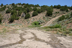
Mahoney Mine, adit mouth.
| |
|
Behind the bushes just to the right of center (outlined). The rephoto stance is also outlined.
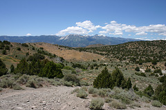
Jumbo site
| |
|
This is about 100 yards SE of the photo stance for the 1936 postcard, and gives a much better impression of the changes because there aren't big junipers in the way!
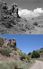
Road to Jumbo
| |
|
The upper photo is from the Gus Bundy collection (#08-167) at the University of Nevada, Reno and was probably taken in the mid-1930s. The lower photo is by me, 14 July 2011. Looking upstream (north), about a quarter of a mile below the old Jumbo townsite, which is right around the corner.
Not too many changes here! Even the road, which elsewhere is now very washed out, doesn't look very different. It does appear that I've captured the same three juniper trees (outlined) as Bundy did, straight ahead across the drainage. They've gotten lots bigger in the last 75-odd years!
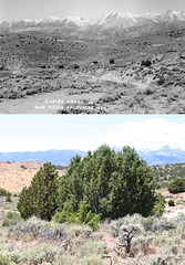
Jumbo then & now
| |
|
Jumbo, Nevada, ca. 1936 and 2011. Top photo courtesy of Nevada Historical Society (uncredited postcard); bottom photo by me, 14 Jul 2011.
In fact, the actual original photo stance is somewhere under those juniper trees in the foreground. This was a hard photo to recover, and not just because of all the vegetation that's grown up. It turns out the road in the foreground of the original pic no longer exists, too. It's been realigned to run up along the wash at right, presumably because of washouts over the years. I ended up matching the stance by lining up the rocky outcrop on the left of the hill in the middle distance (outlined) against the Carson Range (the skyline), and also by comparing the location of the distinctive whitish rhyolite roadcut in the middle of the picture.
I've put a photo from a different position, from about 100 yards southeast, in the comments that gives a much better flavor of the changes. None of the buildings or surface mine workings exist now, and the piñon/juniper forest has made a huge comeback. I imagine the trees had all been logged off in the 1860s to fire the boilers in Virginia City, about 5 miles behind me over the Virginia Range. The wildfire scar on the left in the modern photo dates to a few years ago. It was lightning-caused, IIRC.
I've also highlighted the headframe of the Pandora shaft. This shaft was filled in several years back by the BLM, as part of their mine-safety program.
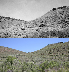
Near Jumbo
| |
|
About a half mile downstream from the main town site, just above the old mill foundation:
www.flickr.com/photos/34117538@N08/5552654863/in/set-7215...
Upper photo is courtesy Nevada Historical Society, and is probably by Gus Bundy, ca. mid 1930s; lower photo is by me, 14 July 2011. The photos are looking roughly east up a side canyon off Jumbo Grade.
Not much left of the old buildings! In striking contrast to the view above Jumbo itself, there were also more piñon/juniper trees in the 1930s than now, especially on the slope to the left. This evidently is the result of a fire a few decades back; there are lots of snags on that slope, and some are even skylined in the modern photo (view at large scale). It's also possible that that fire finished off what was left of the buildings.
There is a modern cultural feature: a tall communications tower right on the range crest to the right of the bluff peeking out in the middle of the canyon (outlined; view large). It was built only a couple of years ago.
The photo stance was hard to recover; it's now down in the steep gully formed by the 1997 flood. Apparently there had been some surface build-up due to sedimentation since the 1930s that was subsequently channeled by the flood. I'm sure Bundy took his photo from what then was the ground surface.
