The Red Burn, Ben Nevis 10th May 1993.
Looking back at the Summit Plato of Ben Nevis 10th…
Carnmore Crag from Loch Tollaidh 23rd June 1999
Arkle across Loch Stack 24th June 1999
The Triple Buttress of A`Coinneach Mhor, Beinn Eig…
Ben Stack 2365Ft
Shenavall Bothy and Ben Dearg Mor
Sgurr An Fhidhleir from Lochan Tuath,Ben Mor Coiga…
Beinn an Eoin from Coire Dubh Mor 22nd June 1999
Wild Boar Fell from Ais Gill 24th February 2018
A.D. on the climb to the CMD arete 16th May 1994.
Derwent Water and Skiddaw from Ashness Bridge 6th…
Alan on the Crinkle Crags with Bow Fell beyond,Lak…
Alan on Loughrigg Fell with Windermere beyond 1997…
A.D on summit plato Ben Nevis 16th May 1994
Alan & Neil at the summit Cairn Sgurr Mhor, Beinn…
Alan and Steve near The Red Burn,Ben Nevis Path 16…
Alan at summit Trig Post Bidein a` Ghlas Thuill, A…
Alan,Malc, Jim and Neil at Shenavall Bothy 13th Ma…
Alan climbing Jacks Rake on Pavey Ark, Langdale Pi…
Bill Hart looking out over Toll An Lochain, An Te…
Bill Hart & Alan Drury at Summit of Beinn an Eoin…
Bill Hart on the An Teallach ridge with Glas Mheal…
Dave Woodhouse on Bidein a`Ghlas Thuill,An Teallac…
Jim And Steve decsending from the Lost Valley into…
Jim between Ruadh Stac Mor and Spidean Coire nan C…
Jim Simpson climbing up from Coire Mhic Fhearchair…
Jim Simpson at summit Cairn of Ruadh stac Mor, Bei…
Jim, Neil and Alan at The Bealach Na Ba (Pass of T…
Jim`s last time on the Ben with us 16th May 1994.…
Steve,Alan and Jim at Summit of Carn Laith, Creag…
Steve and Jim at Hollow Stones with Scafell behind…
Location
Lat, Lng:
You can copy the above to your favourite mapping app.
Address: unknown
You can copy the above to your favourite mapping app.
Address: unknown
See also...
Keywords
Authorizations, license
-
Visible by: Everyone -
All rights reserved
-
245 visits
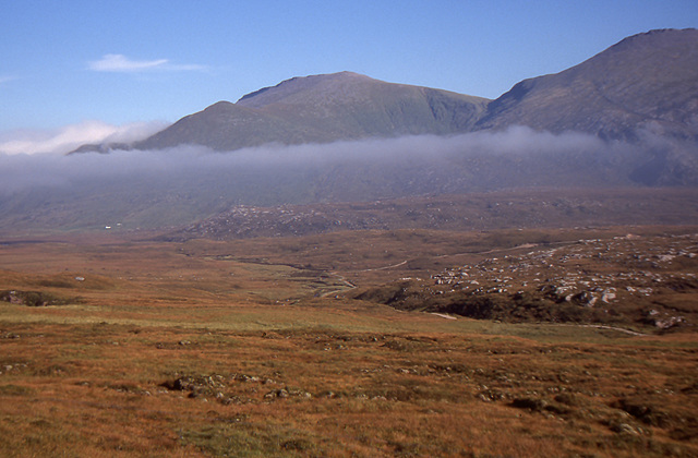
Beinn Spionnaidh and Cranstackie 22nd September 1998.


Beinn Spionnaidh is a mountain of 773 m in Sutherland, the northwestern tip of the Scottish Highlands. It is a Corbett located west of Loch Eriboll and northeast of Cranstackie and Foinaven. It is like its neighbours in that the top, a 1 km long whaleback running southwest to northeast, is covered with loose, broken quartzite. A steep spur to the northwest, Cioch Mhor, provides one route to the top, and good views of the Kyle of Durness; the gentler slope to the southeast is tiring due to the loose rock on the upper section.
Cranstackie is a mountain of 801 m in Sutherland, the northwestern tip of the Scottish Highlands. It is a Corbett located west of Loch Eriboll and northeast of Foinaven. Like Foinaven and Beinn Spionnaidh to the northeast, its top is covered with loose, broken quartzite. The slope is much steeper on the west side than the east, but neither approach is easy due to the covering of loose rock.
Cranstackie is a mountain of 801 m in Sutherland, the northwestern tip of the Scottish Highlands. It is a Corbett located west of Loch Eriboll and northeast of Foinaven. Like Foinaven and Beinn Spionnaidh to the northeast, its top is covered with loose, broken quartzite. The slope is much steeper on the west side than the east, but neither approach is easy due to the covering of loose rock.
Sarah O', Steve D, Fred Fouarge have particularly liked this photo
- Keyboard shortcuts:
Jump to top
RSS feed- Latest comments - Subscribe to the comment feeds of this photo
- ipernity © 2007-2025
- Help & Contact
|
Club news
|
About ipernity
|
History |
ipernity Club & Prices |
Guide of good conduct
Donate | Group guidelines | Privacy policy | Terms of use | Statutes | In memoria -
Facebook
X

Liked by me and saved in fav's
Best wishes ... Steve
Alan Drury club has replied to Steve DBest wishes, hugs Sarah
Alan Drury club has replied to Sarah O' clubSign-in to write a comment.