
RHH's photos


Mulberry Caisson
When we visited the D-day sites at Arromanches we walked the beach and saw there the remains of the artificial harbors used bring in supplies. These harbors were code-named "Mulberries" and were later destroyed by a storm. The remains of one of them are on the beach and out at sea at Arromanches. The photo shows one of the caissons, which were towed across the English Channel on D-day, and which is now on the beach, and another out in the water off the beach. The inset shows the aftermath of a lunch of mussels enjoyed at La Baraka in Arromanches.

Mussels
When we visited the D-day sites at Arromanches we had lunch at La Baraka, mussels with a glass of cider. My mussels were served with Camembert sauce and were incredibly good.

Arromanches-les-Bains
Taken from the cliffs to the east this is the beach and town of Arromanches-les-Bains. We visited and explored the area and walked the beach on one of the last days we were in Normandy. We finished the day at a cafe, La Baraka, in Arromanches and had a glass of cider and a pot of mussels there. On D-Day, Arromanches was at the center of Gold Beach, one of the British landing beaches and is famous for the artificial harbor that was set up there. The harbor was made of enormous concrete caissons towed across the English Channel and sunk at Arromanches to form the harbor. Remains of the harbor, visible in the photo, destroyed by a storm after D-Day, can still be seen in the water off the cliffs and on the beach.

Cider
One of the last places we visited in Normandy was Arromanches, on D-Day the center of Gold Beach, one of the British landing beaches. We explored the area, walked the beach and finished the day with a glass of cider and a bucket of mussels at La Baraka.

La Manneporte
The arch is La Manneporte and we were hiking the cliffs from Etretat to the Antifer Lighthouse when the photo was taken.

Sorcerer's Cave
The Sorcerer's Cave (le Trou de la Sorciere) is high in the cliffs above Tilleul Beach. We were hiking the cliffs from Etretat to the Antifer Lighthouse when we visited the cave.

Plage des Tilleuls
One of the evenings we were in the Etretat area - we stayed in Le Tilleul - we watched the sunset from the Le Tilleul Beach. The photo looks west from the Sorcerer's Cave.

Plage des Tilleuls
These are the cliffs at Plage des Tilleuls near Etretat. We were staying in Le Tilleul and walked to the beach to watch the sunset.
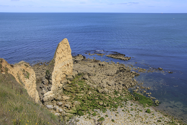
Pointe du Hoc
Here is the part of Omaha Beach below Pointe du Hoc, the place where the US Army Rangers scaled the cliffs to attack the fortifications above after the landings at Omaha Beach had stalled.
