
Extentional faults detail: Saundersfoot south
Small thrust and footwall syncline
Rock Solid.
Seagul Enjoying The Sun,
On the Rocks.
in den Wind gestellt ...
Australio
Australio
Namibia, Huge Boulders in the Mowani Mountains
In A Hollow
La Sierra de La Cabrera,
Fall
Valley, Rocks And Hills.
Rings Loop Trail
Pristine
A Land Of Rocks,
Natures Sculpture
Scarp edge of Houndkirk Hill
Summit rocks of Houndkirk Hill 1
Summit rocks of Houndkirk Hill 2
The Kingdom of the White Stork
Summit rocks of Houndkirk Edge looking NE to Hound…
Rock Pile
Zwei junge Alpen-Murmeltiere ... sehr neugierig !
Lattice Windows sea arches and Barafundle Bay
Sandy Pit doline panorama
Box Bay with caves
Callanish Stones, HFF
Victoria Bay bedding planes in Silurian sandstones
Victoria Bay and Skokholm Island
St Brides Haven solifluction deposit
Druidston Haven: Cliff Section 6 interpretation
Druidston Haven: Cliff Section 4 interpretation
Druidston Haven: Cliff Section 1 interpretation
Gathering Of Water Birds.
Conglomerate at Gravel Bay: close-up view 2
Conglomerates at Gravel Bay
Conglomerate at Gravel Bay: close-up view 1
Primavera
Namibia, The Stone with Ancient Rock Carvings in t…
Marros west - Teague's Wood and drift-filled valle…
Marros west cliffs
Marros west - cryogenic anticline and solifluction…
Little Settlands - inverted thin coals and disturb…
Little Settlands - incompetent deformation 1
1/125 • f/6.3 • 21.0 mm • ISO 400 •
Canon EOS 600D
EF-S15-85mm f/3.5-5.6 IS USM
Location
See also...
Keywords
Authorizations, license
-
Visible by: Everyone -
All rights reserved
-
102 visits
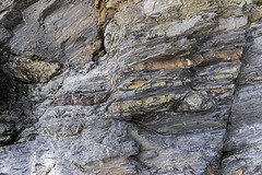
Extentional faults: Saundersfoot south


Saundersfoot to Swallowtree Bay geological structures
Just south of Saundersfoot harbour, immediately adjacent to the previous photo, a set of extensional ('normal') faults with a small displacements cut Lower Coal Measures rocks: mostly mudstones with ironstone bands and nodules, with thin sandstone bands and laminae in the upper part.
The small thrust with a footwall syncline in the previous photo is just visible at the lower right.
The walking stick is 0.9 m long.
Detailed part of photo here:
- Keyboard shortcuts:
Jump to top
RSS feed- Latest comments - Subscribe to the comment feeds of this photo
- ipernity © 2007-2024
- Help & Contact
|
Club news
|
About ipernity
|
History |
ipernity Club & Prices |
Guide of good conduct
Donate | Group guidelines | Privacy policy | Terms of use | Statutes | In memoria -
Facebook
Twitter
Sign-in to write a comment.