St Brides Haven: colourful rocks, colourful sea
Victoria Bay and Skokholm Island
Victoria Bay bedding planes in Silurian sandstones
Couchant Porsay.
Cabo da Roca, Portugal HFF
We're Camping!! This is Humbug Mountain State Park…
Gateholm and Skokholm Islands
Le visiteur !
Pour mes amis dans l'hexagone, meilleurs voeux pou…
Bord de mer pour artistes peintres...
Ralph's Cupboard, Cornwall
Bassa Marea. Alba sull' Adriatico
Un 14 juillet Au large de La Ciotat
...where elements of nature are imbued with feelin…
Box Bay with caves
Sandy Pit doline panorama
Lichens and Viper's Bugloss on Mowingword Point
Box Bay panorama
Stackpole Head from Mowingword Point
Lattice Windows sea arches and Barafundle Bay
HFF - Ein Kreuz mit den Paletten
Fence with ocean - HFF
Newdown's Head, St Agnes, Cornwall
Druidston Haven: Cliff Section 1 panorama
Druidston Haven: Cliff Section 6 interpretation
Druidston Haven: Cliff Section 6
GBAS6175 Phoque gris
La sombra de la valla.
... quand la mer se retire ...
A mere corner - of the stunning ... 'Algar Seco'…
Résurgence
Passage !
Dans la dune !
Goeland
Mouette rieuse Chroicocephalus ridibundus - Black-…
Mon plaisir du soir.
Man and his Man, or Bawden Rocks, or Cow and Calf.
... dunes ...
... les pieds dans l'or ...
La falaise nous surveille....!
L 9 à Mordreuc (22)
Paisaje marítimo terrestre
Tiempo borrascoso
Gros Nez
Location
See also...
See more...Keywords
Authorizations, license
-
Visible by: Everyone -
All rights reserved
-
89 visits
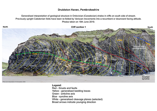
Druidston Haven: Cliff Section 1 interpretation


Druidston Haven geology: Cliff Section 1 interpretation
Interpretation No.1 of a series of six photos and interpretations to illustrate the geology of Druidston Haven, Pembrokeshire. Photo No.1 of a series of six photos and interpretations to illustrate the geology of Druidston Haven, Pembrokeshire. The background is a panoramic view of two photos stitched together using Photoshop software.
The cliffs of Druidston Haven mostly consist of Ordovician (Caradocian) age shales with some thin sandstones. During the Caledonian orgogeny at the end of the Silurian period, these were deformed into a series of mostly upright open folds. These were then re-folded by Variscan movements at the end of Carboniferous, to become largely recumbent (near horizontal) or partly inverted, facing down towards the south.
The Ordovician rocks form a horst - a ridge or block of strata faulted against younger rocks on either side. The Druidston Horst is bounded by the South Druidston Boundary Fault at the south end of the Haven, and the North Druidston Boundary Fault at the north end. These photos show the section midway along the horst from the stream to the Southern Boundary Fault at the far end.
- Keyboard shortcuts:
Jump to top
RSS feed- Latest comments - Subscribe to the comment feeds of this photo
- ipernity © 2007-2024
- Help & Contact
|
Club news
|
About ipernity
|
History |
ipernity Club & Prices |
Guide of good conduct
Donate | Group guidelines | Privacy policy | Terms of use | Statutes | In memoria -
Facebook
Twitter

Sign-in to write a comment.