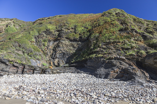
Little Haven - The Settlands; detail of overturned…
Little Settlands - incompetent deformation 2
Little Settlands - incompetent deformation 1
Little Settlands - inverted thin coals and disturb…
The Settlands sand trees 1
The Settlands sand trees 2
Conglomerates at Gravel Bay
Conglomerate at Gravel Bay: close-up view 1
Conglomerate at Gravel Bay: close-up view 2
Moody sky over Freshwater West
Spray haze over Freshwater West
Freshwater West walkies
Gravel Bay - Moor Cliffs Formation
East Pickard Bay panorama
East Pickard Bay - English stonecrop
Waves in Freshwater West
Druidston Haven: Cliff Section 6
Druidston Haven: Cliff Section 6 interpretation
Druidston Haven: Cliff Section 5
Druidston Haven: Cliff Section 5 interpretation
Druidston Haven: Cliff Section 4
Druidston Haven: Cliff Section 4 interpretation
Druidston Haven: Cliff Section 3
Little Haven - The Settlands; detail of incompeten…
Little Haven - The Settlands; detail of southern a…
Little Haven - The Settlands; recumbent fold, thru…
Little Haven - The Settlands; recumbent fold, thru…
Little Haven - The Settlands panorama - geological…
Fox Hole Anticline - northern limb jointing with c…
Little Haven - Fox Hole Anticline
Little Haven north side panorama
Trefrane Cliff Colliery chimney 4
Trefrane Cliff Colliery chimney 2
Rickets Head Black Cliff Colliery tip and Newgale
Rickets Head south mining activity panorama
Rickets Head end-on view
Rickets Head north mining activity panorama
Barafundle Bay, Pembrokeshire
Illuminated bedding planes at Marloes
Looking up the Chimneys
Tenby North Sands skyscape from Castle Hill 2
Tenby North Sands with Inshore Rescue Boat station
Green Bridge of Wales
Elegug Stacks
St Govan's Chapel 1
1/160 • f/7.1 • 15.0 mm • ISO 200 •
Canon EOS 600D
EF-S15-85mm f/3.5-5.6 IS USM
Location
See also...
Keywords
Authorizations, license
-
Visible by: Everyone -
All rights reserved
-
90 visits
Little Haven - The Settlands; detail of incompetent deformation (2)


Structural geology of Little Haven and The Settlands
The cliffs from Little Haven to Broad Haven (and northward) display a spectacular range of geological structures, folding, faulting and thrusting, mainly in the Lower Coal Measures. The relatively weak mudstone and shale-dominated sequences show much incompetent deformation: tight, thrusted and overturned folds, in contrast to the thicker, stronger, sandstones which have formed relatively open and concentric folds.
This is a closer view of the complexly folded and thrusted sequence in the central part of the The Settlands. The relatively weak mudstone and shale sequence has deformed incompetently.
In the centre, an anticline with a vertical/slightly overturned northern limb is separated by a near-horizontal thrust from the gently dipping shales just above the beach pebbles.
To the right, a curved slice of siltstones/thin sandstones is itself thrusted over the horizontal thrust. The dark shale bed in the centre of the photo is approximately at the horizon of the Amman Marine Band, which can be followed, despite the structural complexity, northwards (left) to The Rain headland.
See notes for individual descriptions of areas on the photo.
Fred Fouarge has particularly liked this photo
- Keyboard shortcuts:
Jump to top
RSS feed- Latest comments - Subscribe to the comment feeds of this photo
- ipernity © 2007-2024
- Help & Contact
|
Club news
|
About ipernity
|
History |
ipernity Club & Prices |
Guide of good conduct
Donate | Group guidelines | Privacy policy | Terms of use | Statutes | In memoria -
Facebook
Twitter

Sign-in to write a comment.