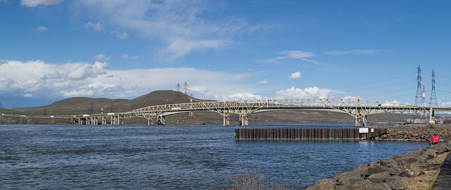
Umatilla Bridge (#0359)
Plymouth WA (#0410)
Plymouth WA (#0411)
McNary Dam WA (#0406)
McNary Dam WA (#0409)
Port Kelley WA (#0364)
Port Kelley WA (#0372)
Port Kelley WA (#0368)
Port Kelley WA (#0370)
Port Kelley WA (#0374)
Port Kelley WA (#0373)
Pasco WA BNSF Burbank bridge (#0381)
Pasco WA Snake river (#0383)
Pasco Kennewick Cable bridge (#0389)
Pasco WA BNSF Burbank bridge (#0376)
Pasco Kennewick Cable bridge (#0395)
Pasco WA BNSF Kennewick bridge (#0393)
Kennewick dusk (#0509)
Kennewick dusk (#0397)
Kennewick (#0404)
Portland Linnton rail (#0499)
Portland Linnton rail (#0501)
Sauvie Island (#0503)
John Day Columbia Aluminum (#0426)
John Day Columbia Aluminum (#0419)
John Day dam (#0425)
John Day lava field (#0423)
Columbia Gorge rail line (#0416)
Columbia Gorge barge (#0353)
John Day dam fish ladder (#0350)
John Day dam (#0349)
John Day dam avian predation (#0346)
John Day dam avian predation (#0347)
John Day dam smolt chute (#0344)
John Day dam (#0351)
John Day dam (#0338)
John Day dam (#0336)
John Day dam (#0341)
John Day dam (#0334)
Biggs Jct Spanish Hollow bridge (#0332)
Palm Springs Orlando memorial (#0648)
Maryhill WA Stonehenge memorial (#0427)
Maryhill WA Stonehenge memorial (#0429)
Maryhill WA Stonehenge memorial (#0430)
Maryhill WA Stonehenge memorial (#0432)
Location
See also...
Keywords
Authorizations, license
-
Visible by: Everyone -
Attribution + non Commercial + no derivative
-
185 visits
Umatilla Bridge (#0356)


Umatilla Bridge, carrying I-82 and US-395 over the Columbia River. From this angle, the two spans of the bridges were optically confusing, making it difficult to tell what bridge was carrying the traffic.
There was no opportune spot to photograph something else that was occurring very close to this site. Just on the east side of the spans was a major construction site that looked like it was the construction of a server farm (data center) due to the type of structures and the security around the construction. With a little searching, I found that my suspicion was correct. Amazon, which operates three server farms in the general area, was expanding its data center at the port of Umatilla. See: www.eastoregonian.com/eo/local-news/20170317/amazon-keeps-building-data-centers-in-umatilla-morrow-counties
There was no opportune spot to photograph something else that was occurring very close to this site. Just on the east side of the spans was a major construction site that looked like it was the construction of a server farm (data center) due to the type of structures and the security around the construction. With a little searching, I found that my suspicion was correct. Amazon, which operates three server farms in the general area, was expanding its data center at the port of Umatilla. See: www.eastoregonian.com/eo/local-news/20170317/amazon-keeps-building-data-centers-in-umatilla-morrow-counties
Clint has particularly liked this photo
- Keyboard shortcuts:
Jump to top
RSS feed- Latest comments - Subscribe to the comment feeds of this photo
- ipernity © 2007-2024
- Help & Contact
|
Club news
|
About ipernity
|
History |
ipernity Club & Prices |
Guide of good conduct
Donate | Group guidelines | Privacy policy | Terms of use | Statutes | In memoria -
Facebook
Twitter

Don Barrett (aka DBs… club has replied to slgwv clubSign-in to write a comment.