
Roulston Scar with haze over the Vale of York (1 x…
Vale of York & Vale of Mowbray (1 x PiP)
Summer Haze
Island of Soay from Camasunary Bay
Rowan by the River
La Sierra de La Cabrera, granite territory.
Turbulent clouds over Glen Etive
River Etive
Loch Etive
The family gathers for a pre-scavange conflab!
Whinlatter Forest (HFF everyone)
Lozoya Valley fog. H. A. N. W. E. everyone!
Granite country
Voisthalerhütte, Alt & neu / Old & new
Wasedale and Wastwater in Autumn colours
Bankraub / Bank robbery
Lichtung / Clearing
Sonnenaufgang im Seetal / Sunrise at Lake Valley
Over the hills and far away.....
Spätsommermorgen / Late summer morning
Mondalindo and the Bustarviejo Valley from The Sie…
Las Agujas de Cancho Gordo
Peña del Tejo
Pico de La Miel
La Sierra de La Cabrera
The path down to Valdemanco
Late afternoon light on the River Garry
Not to be trusted (HFF Everyone)
Catbells over Derwent Water
Fishing Cove, Nudist beach, Reskajeage, Cornwall (…
Valley of Bustarviejo from the Sierra de La Cabrer…
Rock window. H. A. N. W. E. everyone!
Ennerdale Water (HFF Everyone)
More splendid granite walking country.
High above the cloud / fog. Las Agujas de El Canch…
Las Hurdes, Cacares Province, Extramadura, evening…
Sierra de La Cabrera granite
Rannerdale
Yet another granite one!
Even more granite! High on the ridge.
Sierra de La Cabrera.
Griffon vultures and their guano stained home. Can…
Typical Sierra de La Cabrera granite country.
La Sierra de La Cabrera and monastery
La Sierra de La Cabrera
Location
See also...
Keywords
Authorizations, license
-
Visible by: Everyone -
All rights reserved
-
126 visits
Vale and Hills (1 x PiP)
")

The Hambleton Hills and Vale of Mowbray from Roulston Scar (Sutton Bank)
The view is to the north
The Hambleton Hills are a range of hills in North Yorkshire, England. They form the western edge of the North York Moors but are separated from the moors by the valley of the River Rye. They are the eastern boundary of the low-lying Vale of Mowbray which they abut with a precipitous escarpment.
They run in a north–south direction for about 15 miles (24 km) and merge with the Cleveland Hills in the north and Howardian Hills in the south.
The hills are made up of rocks of middle and late Jurassic age with the hard Corallian Limestone forming the cap at the highest points. The highest point is Black Hambleton which rises to 1,308 feet (400 m) at the northern end of the range. Roulston Scar reaches 919 feet (280 m) and Whitestone cliff is 1,063 feet (324 m).The Corallian Limestone also outcrops along the southern edge of the North York Moors forming the Tabular Hills which run from Black Hambleton eastwards to Scarborough, although much broken through by river valleys.
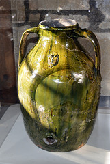
In the 12th and 13th centuries, the Hambleton Hills was the production centre for York Glazed Ware, a type of Medieval ceramic. The example below is displayed at Helmsley Castle 13 miles (20 km) to the east.
Sutton Bank (also known as Roulston Scar) is a high point on the Hambleton Hills with extensive views over the Vale of York and the Vale of Mowbray. The hill is the site of one of the most important prehistoric monuments in the region, an Iron Age hill fort built in around 400 BC.
The Hambleton Drove Road runs along the summit of the hills, it is part of an ancient highway running from Scotland to the south of England. It is thought to be prehistoric and various burial grounds from the Neolithic and Bronze Ages are evident along its route. Large-scale movement of cattle from Scotland to market in England during the 18th and 19th centuries have given it the name by which it is known today.
The view is to the north
The Hambleton Hills are a range of hills in North Yorkshire, England. They form the western edge of the North York Moors but are separated from the moors by the valley of the River Rye. They are the eastern boundary of the low-lying Vale of Mowbray which they abut with a precipitous escarpment.
They run in a north–south direction for about 15 miles (24 km) and merge with the Cleveland Hills in the north and Howardian Hills in the south.
The hills are made up of rocks of middle and late Jurassic age with the hard Corallian Limestone forming the cap at the highest points. The highest point is Black Hambleton which rises to 1,308 feet (400 m) at the northern end of the range. Roulston Scar reaches 919 feet (280 m) and Whitestone cliff is 1,063 feet (324 m).The Corallian Limestone also outcrops along the southern edge of the North York Moors forming the Tabular Hills which run from Black Hambleton eastwards to Scarborough, although much broken through by river valleys.
In the 12th and 13th centuries, the Hambleton Hills was the production centre for York Glazed Ware, a type of Medieval ceramic. The example below is displayed at Helmsley Castle 13 miles (20 km) to the east.
Sutton Bank (also known as Roulston Scar) is a high point on the Hambleton Hills with extensive views over the Vale of York and the Vale of Mowbray. The hill is the site of one of the most important prehistoric monuments in the region, an Iron Age hill fort built in around 400 BC.
The Hambleton Drove Road runs along the summit of the hills, it is part of an ancient highway running from Scotland to the south of England. It is thought to be prehistoric and various burial grounds from the Neolithic and Bronze Ages are evident along its route. Large-scale movement of cattle from Scotland to market in England during the 18th and 19th centuries have given it the name by which it is known today.
Günter Klaus, Petar Bojić, Andy Rodker, Fred Fouarge and 18 other people have particularly liked this photo
- Keyboard shortcuts:
Jump to top
RSS feed- Latest comments - Subscribe to the comment feeds of this photo
- ipernity © 2007-2024
- Help & Contact
|
Club news
|
About ipernity
|
History |
ipernity Club & Prices |
Guide of good conduct
Donate | Group guidelines | Privacy policy | Terms of use | Statutes | In memoria -
Facebook
Twitter
Doug Shepherd club has replied to Jaap van 't Veen clubAll the best, Doug
Doug Shepherd club has replied to Cheryl Kelly (cher12… clubAll the best, Doug
Doug Shepherd club has replied to ©UdoSm clubAll the best, Doug
Have a good weekend.
Rosa.
Doug Shepherd club has replied to Rosalyn Hilborne clubAll the best, Doug
Doug Shepherd club has replied to Marie-claire GalletAll the best, Doug
Doug Shepherd club has replied to Schussentäler clubAll the best, Doug
I WANNA GO HOME !!!!
BEAUTIFUL PHOTOS AND FANTASTIC GEOLOGY SCRIPT !!!
Doug Shepherd club has replied to Pam J clubenjoy the rest of your day, Doug
Terrific notes and PiP
Beutifully captured. Enjoy your weekend
Doug Shepherd club has replied to Ecobird clubAll the best, Doug
Doug Shepherd club has replied to Ulrich John clubAll the best, Doug
happy sunday:)
Doug Shepherd club has replied to Annemarie clubAll the best, Doug
Thanks for sharing with our UK Landscape Photography Group , Herb
Doug Shepherd club has replied to Herb Riddle clubEnjoy your day, Doug
Doug Shepherd club has replied to Stefani Wehner clubAll the best, Doug
..........wünsche noch einen schönen Nachmittag,ganz liebe Grüße Güni:))
Doug Shepherd club has replied to Günter Klaus clubAll the best, Doug
Sign-in to write a comment.