Four Corners - Bob Lansing, Navajo Artist
Ho′zho′
Tabitha
Conestoga Wagon - Chinle, AZ
The Holiday Inn - Chinle, AZ
The Holiday Inn - Chinle, AZ
The Holiday Inn - Chinle, AZ
The Holiday Inn - Chinle, AZ
Navajo Shoulder Patch (Navajo Tribal Police)
Hogan - Canyon de Chelly, AZ
Canyon de Chelly, AZ
Canyon de Chelly, AZ
Canyon de Chelly, AZ
Canyon de Chelly, AZ - Antelope House
I See You...
Canyon de Chelly, AZ
Canyon de Chelly, AZ (Canyon del Muerto)
Canyon de Chelly, AZ (Canyon del Muerto)
Canyon de Chelly, AZ
Canyon de Chelly, AZ (Canyon del Muerto)
Ben Teller: "They Shot Us Down Like Dogs"
Canyon de Chelly, AZ (Canyon del Muerto)
Canyon de Chelly, AZ (Canyon del Muerto)
Cliff Palace - Mesa Verde National Park
Mąʼii (coyote) - Mesa Verde National Park, CO
El Burro Pancho - Cortez, CO
Kissing Rocks - Bluff, UT
Kissing Rocks - Bluff, UT
Bluff, UT
I Like It !!
Let's Trade!
Navajo Roadside Kiosk
Mile Marker 13, UT - along Hwy 163
Mile Marker 13, UT - along Hwy 163
What Is It?
The View Hotel - Monument Valley, AZ
The View Hotel - Monument Valley, AZ
Tsé Biiʼ Ndzisgaii
The View Hotel - Monument Valley, AZ
Hello and Goodbye to Ancient Spirits
The Monuments Are Calling, And I Must Go..
Reflections - The View Hotel, Monument Valley, AZ
Evening Sunset at the View Hotel - Monument Valley…
Dinner At The View Hotel - Monument Valley, AZ
Menu - The View Hotel, Monument Valley, AZ
Location
See also...
Keywords
4 Corners Monument


DAY 8
THUR 4 OCT 2012
Drive: from Cortez/Mesa Verde, CO to Chinle, AZ
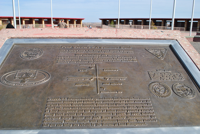
During our drive, we stop at the four corners monument; so named because of where four state boundary lines meet and intersect. The Colorado corner lies in the Ute Mountain reservation, while the Utah, Arizona and New Mexico corners lie in the Navajo Nation.
This information plaque bears the insignia's of the U.S. Dept. of the Interior, 1848 (top left), U.S. Public Land Survey System (bottom left), U.S. Dept. of the Interior,/Bureau of Land Management (top right), and the Great Seals of the Navajo Nation, and Ute Mountain Ute Tribe (Towaoc, Colorado).
Above the Great Seals of the Navajo & Ute, the words read:
Indian Lands
The four corners area is surrounded by
Indian Lands. The Navajo Nation lies in
New Mexico, Arizona and Utah. The
Ute Mountain Ute Nation is located in
Colorado. Respect the culture and
traditions of the four corners area."
The plaque (middle section) reads:
Four Corners -- A Common Bond
This is the only place in the United States marking the common
corner of four states -- Colorado, New Mexico, Arizona and Utah.
Who established this corner?
The four corners monument was established and perpetuated by
U.S. Government Surveyors and Astronomers beginning in 1868.
Surveyors Ehud Darling (1868), Chandler Robbins (1875), Rollin Reeves (1878) and Howard Carpenter (1901) surveyed the boundary lines between the states.
In 1899, U.S. Surveyors Hubert Page and James Lentz found the four corners
monument disturbed and broken. They marked and set a new stone at the
original location. Everett Kimmell, General Land Office, remonumented the
Page-Lentz stone with a concrete and brass monument in 1931. The Bureau
of Land Management and the Bureau of Indian Affairs poured a concrete
paving block around the Kimmell monument in 1962. In 1992, Cadastral
Surveyors Darryl Wilson and Jack Eaves officially remonumented the
deteriorating Kimmell marker with an aluminum bronze disc. The structure
that you see today was rebuilt by the Bureau of Land Management.
- Keyboard shortcuts:
Jump to top
RSS feed- Latest comments - Subscribe to the comment feeds of this photo
- ipernity © 2007-2024
- Help & Contact
|
Club news
|
About ipernity
|
History |
ipernity Club & Prices |
Guide of good conduct
Donate | Group guidelines | Privacy policy | Terms of use | Statutes | In memoria -
Facebook
Twitter

Sign-in to write a comment.