Arizona and Utah
USA - Arizona, Petrified Forest National Park
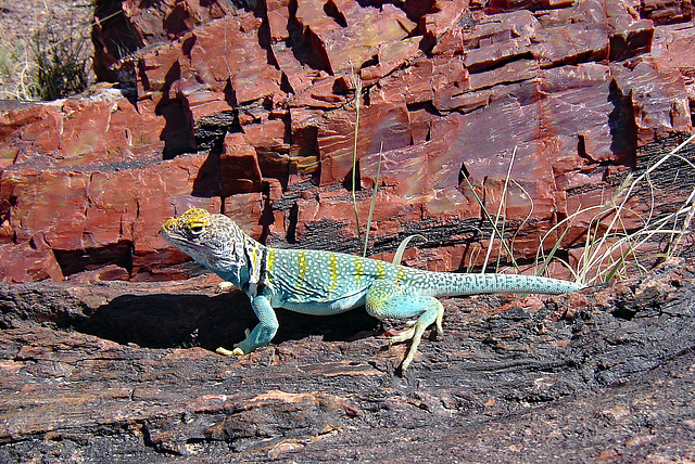
Petrified Forest National Park is well known for its abundant number of fossils, especially fallen trees that lived in the Late Triassic Period, about 225 million years ago. The park is home to some of the most impressive fossils ever found and more are being discovered each year as erosion exposes new evidence. Fossils found here show the forest was once a tropical region, filled with towering trees; more than 150 different species of fossilized plants have been discovered.
When trees were toppled by volcanic eruptions, they were swept away by flowing water and deposited in marshes and covered with mud and volcanic ash. Buried under layers of sediment, the logs remained buried for millions and millions of years undergoing an extremely slow process of petrification, which essentially turned the logs to colourful stone. Much of the park’s petrified wood is from Araucarioxylon arizonicum trees (an extinct species of conifer).
The beautiful colours in the petrified wood come mainly from three minerals: pure quartz is white; manganese oxides form blue, purple, black and brown; and iron oxides provide hues from yellow through red to brown.
Theodore Roosevelt created Petrified Forest National Monument on December 8, 1906. Petrified Forest was designated as a national park on December 9, 1962.
(Main picture was taken along the Giant Logs Trail, behind the rainbow Forest Museum. The colourful collared lizard is quite common in the park during summer months.)
USA - Arizona, Petrified Forest National Park
Petrified Forest National Park is well known for its many chunks of petrified logs
( www.ipernity.com/doc/294067/45523794 ), but it offers more fascinating and intriguing scenery.
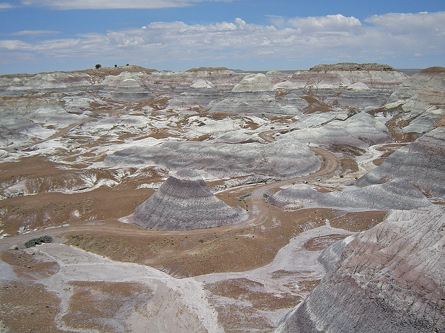
The Blue Mesa area of the park is part of the second-oldest layer of the so called Chinle Formation, deposited approximately 220 - 225 million years ago. This formation can be seen across the park with the multi-coloured Painted Desert (PiP 1) and the Blue Mesa badlands.
Blue Mesa (main image) - easy accessible by a three mile long loop road - is a very desolate landscape of mudstone and sandstone layers in blue, purple and greys. The landforms have been sculpted by erosion. The Tepees (PiP 2) is a part of Blue Mesa with tall, cone-shaped hill striped with almost perfect layers of reds, pinks, blues, greys, purples, and white.
Arizona - Monument Valley
Monument Valley - or officially Monument Valley Navajo Tribal Park - is without doubt one of the most striking examples of the breathtaking beauty of the empty desert in the southwest of the USA. The vast plain serves as a backdrop for the silhouettes of the red rock formations. With its natural beauty it is one of the most majestic and photographed places on earth.
Before human existence, the area was a lowland basin. For hundreds of millions of years, materials that eroded from the Rock Mountains deposited layer upon layer of sediment which cemented a slow and gentle uplift, generated by ceaseless pressure from below the surface. These horizontal strata were quite uniformly elevated one to three miles above sea level and the basin became a plateau.
Millions of years ago there were many more rocks in this area, which consisted of various types of sandstone rock. The softer layers are worn away by the natural forces of wind and water, causing the so-called mesas. These are wide rocks that are flat at the top. The continuous erosion process ensures that even a mesa wears away very slowly. The harder top layer wears less quickly than the softer sides, so a mesa gets narrower and narrower. If the width of rock is eventually smaller than its height, it is no longer a mesa, but a butte. Also the butte slowly wears away, until a spire remains. Even those rock needles will slowly disappear completely.
Most of the park is located in Arizona, the northernmost point belongs to the state of Utah.
Window is one of the most visited stops so the viewpoint can get rather crowded.
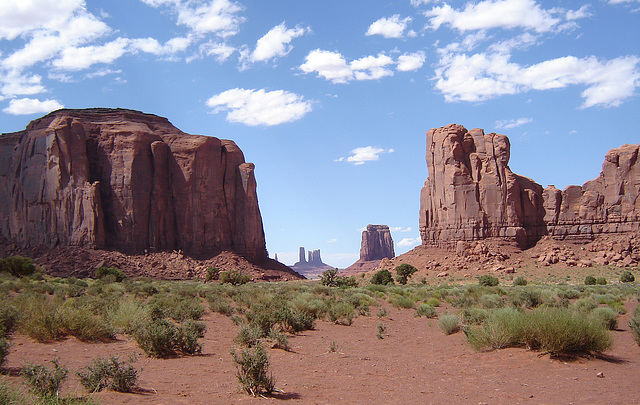
Main picture: North Window, between Elephant Butte and Cly Butte, looking towards East Mitten Butte, with Castle Butte, Bear & Rabbit and Stagecoach in the background
PiP1: the famous panorama with the Mitten Buttes and Merrick Butte
PiP2: Merrick Butte, along the Valley Drive
PiP3: classic image of Monument Valley, taken at mile marker 13 along the road from Mexican Hat (US Highway 163)
USA - Arizona, Canyon de Chelly
A number of canyons within the borders of the Navajo Reservation in Arizona form the National Monument Canyon de Chelly. “Canyon de Chelly” is the translation of the Navajo word “Chéyi”, which means “inside the rock” or “canyon”.
The area received the status of National Monument due to the many archaeological finds that have been made. There is evidence that people have lived here almost continuously for 5.000 years. Canyon de Chelly is not only interesting because of its rich human history, but also because of its impressive nature.
As a matter of fact the National Monument consists of four large canyons and many small side canyons. The shallow muddy Chinle Wash flows through the canyons; the constant presence of water ensures that there is always a lot of vegetation. In the west, the cliffs are less than 10 meters high, but further east the canyons become deeper and deeper. In the east the walls rise about 300 meters above the bottom of the canyons.
Canyon de Chelly is still inhabited by the Navajo Indians and visitors are not allowed to go everywhere.
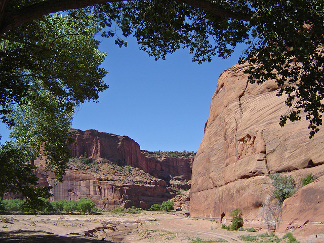
Main image: bottom of the canyon with the Chinle Wash
PiP1: Canyon de Chelly, seen from one of the overlooks along the South Rim Drive
PiP2: Spider Rock is the most famous monolith in Canyon de Chelly.
PiP3: White House - a Puebloan village built into a sheer 500 foot sandstone cliff - was occupied between 1060 AD and 1275 AD. One can visit the ruins through the White House Trail; the only trail by which visitors may enter the canyon without a permit or an official Navajo guide.
USA - Utah, Arches National Park
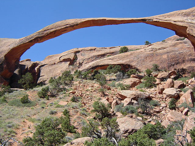
Arches National Park has more than 2.000 natural stone arches. Nowhere else in the world are so many natural rock arches found, as within the boundaries of the park. In addition to the arches the park also offers many other amazingly shaped rock formations, like soaring pinnacles, massive fins and giant balanced rocks. The arches and rock formations have created a red-rock wonderland.
Main picture: Landscape Arch, the longest arch is with a span of 88 meters.
PiP1: Wall Arch, collapsed August 4 2008, just weeks after I took this image.
PiP2: Double Arch, two arches with a common end.
PiP3: Balanced Rock, total height of 39 meters
PiP4: Park Avenue
PiP5: Courthouse Towers
USA - Utah, Bryce Canyon National Park
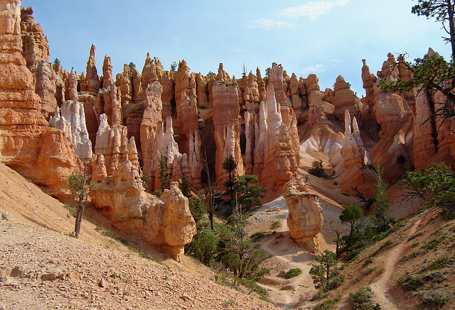
Bryce Canyon is not really a canyon, but a series of strange, naturally formed amphitheatres, carved into the edge of a high plateau. Its walls consist of sixty different layers of sand, limestone and slate. In the amphitheatres there are countless very irregular shaped rock formations in all kinds of shades, varying from white, pastel pink, fiery orange and red to dark red. These spires of rocks (called hoodoos) are caused by erosion.
USA - Utah, Grand Staircase-Escalante National Monument, Devil’s Garden
Devil’s Garden - or officially Devil’s Garden Outstanding Natural Area - is a rather small part of Grand Staircase-Escalante National Monument. It is a real hidden gem, only accessible via a quite bad gravel road and not very well signposted. This has the advantage that there are not so many tourists like in the more well known parks in Utah (during our visit we were just the two of us).
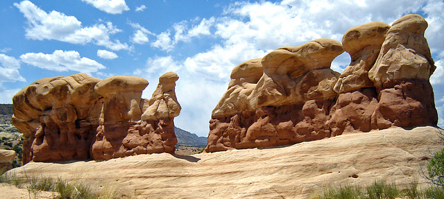
Devil’s Garden consists of a collection of irregularly shaped sandstone rock sculptures, which are the result of wind and water erosion over the centuries. There are three different sandstone layers and one can see very well that the erosive forces on each layer have had a different effect. The bottom layer forms a kind of pedestal, on which are short hoodoos that consist of a narrow dark layer with a wider hood above it that is much lighter colored. Besides the hoodoos you can see many other small rock formations and some arches.
USA - Utah, Canyonlands National Park
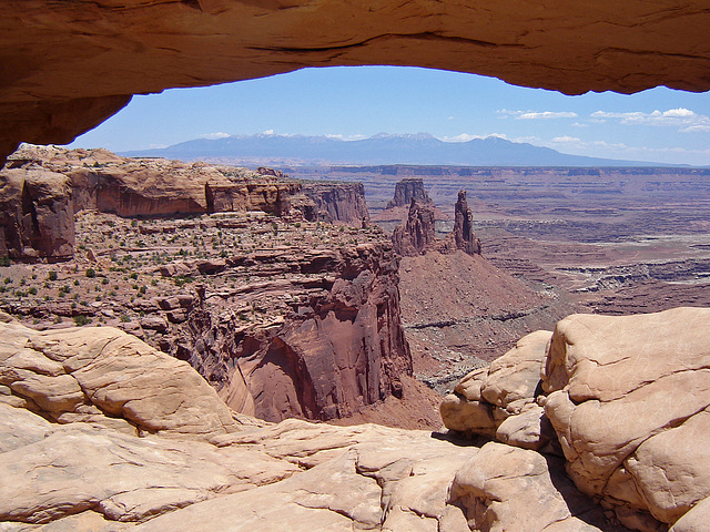
For millions of years, the Green River, Colorado River and their tributaries have carved their way through the rocky landscape of Utah. This has created one of the most rugged areas in the United States, an almost impenetrable labyrinth of gorges with countless natural arches, bridges and the most irregular rock formations. The rivers divide the park into three parts, each with its own character.
With more than 1.300 square kilometers park is Canyonlands the largest national park. The most visited part of the park is the Island in the Sky District, with a couple of overlooks providing spectacular views over the surroundings. With less than half a million visitors per year, this is the least visited National Park in the state of Utah.
Main picture : view through Mesa Arch over the spires and canyons with the La Sal Mountains in the background.
PiP1 : White Rim Overlook with a view of the Colorado River Canyon, and the spires of Monument Basin.
PiP2 : Green River Overlook with the Stillwater Canyon with the Green River.
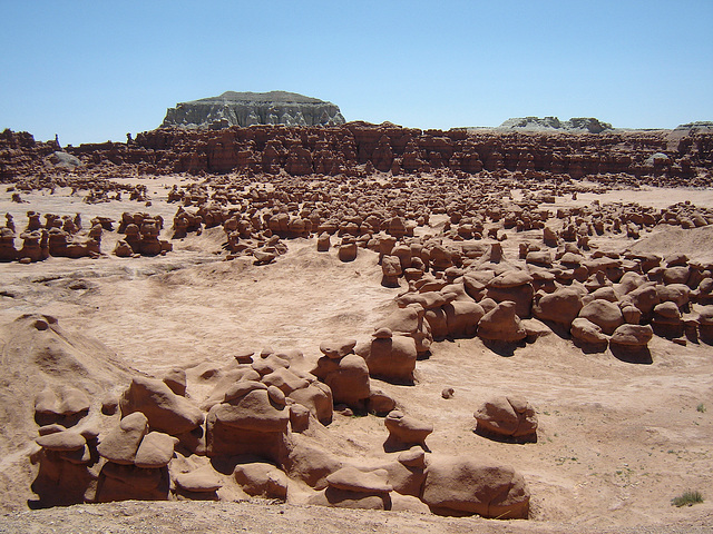
USA - Utah, Goblin Valley State Park
Goblin Valley is a small State Park, about 2 miles long and 1 mile wide. In the valley are thousands of amazingly shaped rock figures, most of them no more than two or three meters high, surrounded by a wall of eroded cliffs. The shapes of these rocks result from an erosion-resistant layer of rock atop relatively softer sandstone.
In 1949 the valley was named "Mushroom Valley", because many of the rock figures resemble mushrooms. Later the name was changed into Goblin Valley, which is also a well chosen name because one can easily see an army of gnomes in these hoodoos. Goblin Valley State Park (and Bryce Canyon National Park) contain some of the largest occurrences of hoodoos in the world.
The goblins, like the surface of the valley, all have the same chocolate brown colour. Plants and flowers can hardly survive in this dry, warm environment, so there is no vegetation at all here.
It is also allowed to walk into the valley and wander between the goblins.
Goblin Valley was granted the status of State Park in 1964.
Jump to top
RSS feed- Latest items - Subscribe to the latest items added to this album
- ipernity © 2007-2024
- Help & Contact
|
Club news
|
About ipernity
|
History |
ipernity Club & Prices |
Guide of good conduct
Donate | Group guidelines | Privacy policy | Terms of use | Statutes | In memoria -
Facebook
Twitter

