Looking toward California
Cloud Cover.
Fenced Off
PCT and Spire off Arnot Peak
Quiet Country Road.
Jim Barnett Reserve Notice.
Dropping into Red Canyon!
White Pigeon
On Track to Bridal Falls
Patea River Bridge.
Quiet Country Road.
Up The Steps
A Place To Sit A While.
Genoa Falls
Red Bridge
Path To River Walk.
Sundown On Our Street
In Main Street Stratford.
Nearing Ohura
Lonely Farm.
Above Lottin Point ,
Salt Water Creek, Timaru
Peaceful country
Forest And Hills
End Of A Track.
Tahoe Meadows and Washoe Lake
Noble Lake
Noble Lake
Green Country .
Tibet in the Sierra?
Sierra Nevada Crest
Rural Scene
Downhill Run
In Jim Barnett Reserve
Above Paekakariki
Grassy Roadside.
Craters Of The Moon Landscape.
In Between The Trees.
Funchal Park Fence (HFF)
Fenced In.
South From Ohura.
Farm entrance
In Stratford Shopping Center
Quiet Road.
Overlooking Rotorua
Location
See also...
Keywords
Authorizations, license
-
Visible by: Everyone -
All rights reserved
-
130 visits
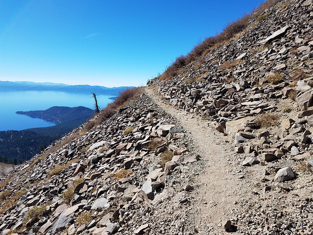
Watch your step...


Tahoe Rim Trail going around Rose Knob Peak, in the Mt. Rose Wilderness area, Humboldt-Toiyabe National Forest, Nevada. Looking southwest over Lake Tahoe; the trail elevation here is about 9400 ft/2865 m. The prominent peninsula on the left is State Line Point. By complete happenstance the California-Nevada boundary nearly bisects the peninsula. The deepest point in the lake, at 1645 ft/501 m, is just off State Line Point. The inset shows the view from the point ahead where the trail curves around the mountain.
Nautilus, Marie-claire Gallet, Pam J have particularly liked this photo
- Keyboard shortcuts:
Jump to top
RSS feed- Latest comments - Subscribe to the comment feeds of this photo
- ipernity © 2007-2024
- Help & Contact
|
Club news
|
About ipernity
|
History |
ipernity Club & Prices |
Guide of good conduct
Donate | Group guidelines | Privacy policy | Terms of use | Statutes | In memoria -
Facebook
Twitter

slgwv club has replied to Pam J clubSign-in to write a comment.