IMG 7527 adj
IMG 7528 adj
IMG 7529 adj
IMG 7538 adj
IMG 7541 adj
IMG 7544 adj
IMG 7552 adj
IMG 7639 adj
IMG 7594 adj
IMG 7595 adj
IMG 7597 adj
IMG 7598 adj
IMG 7600 adj
IMG 7603 adj
IMG 7604 adj
IMG 7605 adj
IMG 7623 adj
IMG 7630 adj
Woods Lake
Woods Lake
IMG 6736 adj
IMG 7298 adj
IMG 7929 adj
IMG 8600 rot
IMG 0040
IMG 8595 rot
IMG 8596 rot
Vista
Tenacity
20180528 105752 001
Pony Express route
Pony Express route
20180528 104833
Cole
Cavernous
Cavernous
The Trail Ahead
Distance
IMG 0877 adj
IMG 0831
IMG 0839
IMG 0844
IMG 0846
IMG 0847
IMG 0859
IMG 0864
IMG 0866
IMG 0869 adj
IMG 0870 adj
IMG 0871 adj
IMG 0872
Godber Mine
Fourth of July Lake
Fourth of July Lake
Fourth of July Lake
Fourth of July Lake
Fourth of July Lake
Fourth of July Lake
Lower Blue Lake
Lower Blue Lake
IMG 1304
IMG 1305
Lower Blue Lake
IMG 7523 adj
IMG 7522 adj
IMG 7520 adj
IMG 7512 adj
IMG 7511 adj
IMG 7509 adj
IMG 7508 adj
IMG 7500 adj
IMG 7499 adj
IMG 7497 adj
IMG 7486 adj
IMG 7483 adj
IMG 7481 adj
IMG 7482 adj
IMG 7592 adj
IMG 7588 adj
IMG 7583 adj
IMG 7579 adj
IMG 3213
IMG 3212
IMG 3207 adj
IMG 3205
IMG 3195 adj
IMG 3192 adj
IMG 3190 adj
IMG 3188 adj
IMG 3187 adj
IMG 3186 adj
IMG 3184 adj
IMG 3182
IMG 3176 adj
IMG 3174 adj
IMG 3167 adj
IMG 3165
IMG 3160 adj
Cole
IMG 3148
IMG 3211
IMG 3210 adj
IMG 3209 adj
IMG 3208 adj
20180503 173905(0)
Mustangs!
20180509 153718 004
20180509 153558
20180509 153414 001
20180509 151937
20180509 154708
20180509 153815 001
20180508 143256 001
20180508 141835 001
Erosion!
Wave-cut bench.
20180508 141111 001
20180508 140835
20180508 140729 001
20180508 145031 001
20180508 143709
20180508 143457 001
IMG 0728
Last Chance Creek
Last Chance Creek
Location
See also...
Keywords
Authorizations, license
-
Visible by: Everyone -
All rights reserved
-
372 visits
Pacific Crest Trail


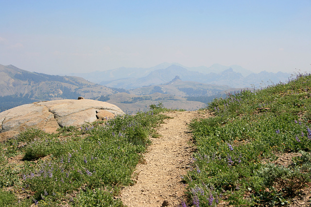
A couple of miles south of Carson Pass, looking southeasterly. The prominent butte in the middle distance is (I kid you not) The Nipple (9342 ft/2847 m). Directly behind it is Markleeville Peak (9415 ft/2870 m), and to the right is (outlined; almost as politically incorrect) Jeff Davis Peak (9065 ft/2763 m). Sierra Nevada, California. The scattered purple-blue flowers are lupine.
Ruebenkraut, Roger (Grisly), William Sutherland and 2 other people have particularly liked this photo
- Keyboard shortcuts:
Jump to top
RSS feed- Latest comments - Subscribe to the comment feeds of this photo
- ipernity © 2007-2024
- Help & Contact
|
Club news
|
About ipernity
|
History |
ipernity Club & Prices |
Guide of good conduct
Donate | Group guidelines | Privacy policy | Terms of use | Statutes | In memoria -
Facebook
Twitter

slgwv club has replied to Andy Rodker clubAdmired in:
www.ipernity.com/group/tolerance
slgwv club has replied to William Sutherland clubslgwv club has replied to Roger (Grisly) clubSign-in to write a comment.