IMG 6984
IMG 6989
IMG 6993
IMG 6994
IMG 6996
IMG 6999
IMG 7002
IMG 7020
IMG 7021
IMG 7026
IMG 7027
IMG 7028
IMG 7031
IMG 7033
IMG 7034
IMG 7035
IMG 7039
IMG 7047
IMG 1710
20170819 124052 001
Thistledown
20170820 145707 001
Upper South Falls
IMG 6976
IMG 6975
IMG 6970
IMG 6964
IMG 6963
IMG 6961
IMG 6957
IMG 6956
IMG 6955
IMG 6954
IMG 6953
IMG 6951
IMG 6948
IMG 6947
IMG 6946
IMG 6944
IMG 6943
IMG 6929
IMG 6928
IMG 6923
IMG 6916
IMG 6910
Location
See also...
Keywords
Authorizations, license
-
Visible by: Everyone -
All rights reserved
-
387 visits
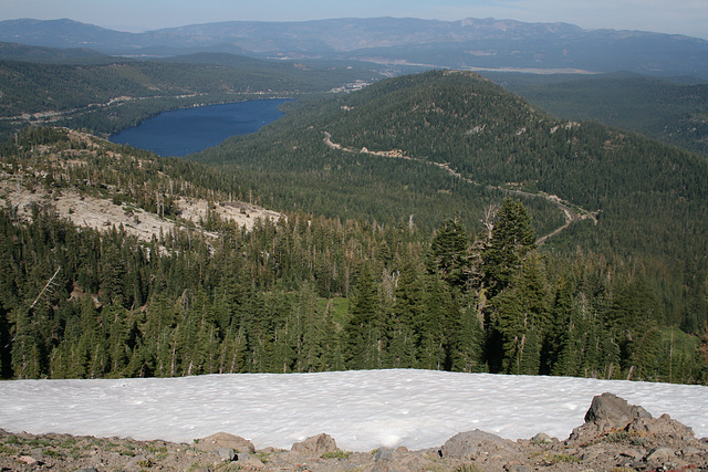
View from Mt. Judah


Looking east. The body of water to the left is Donner Lake; the divided highway climbing the flank of the ridge to the left of it is Interstate 80. The small town of Truckee, California (formerly a timber town, now largely devoted to tourism) is mostly behind the knoll in the middle distance. The Carson Range forms the skyline, with the Nevada-California state line falling somewhere on the slope below. The prominent right-of-way below in the near distance is the current alignment of the transcontinental railroad, now part of the Union Pacific. And yes, that's snow in the immediate foreground!
Mt. Judah, which is about a mile south of Donner Summit, lies in the main Sierra Crest and forms the east side of the Sugar Bowl ski resort. It is named for Theodore Judah, one of the main advocates for construction of the Pacific Railroad, as the transcontinental railroad was then called. The railroad ended up being built largely along the route he'd laid out, but alas he didn't live to see it. He died of yellow fever in 1863, caught while crossing the Isthmus of Panama on his way to Washington, DC to lobby Congress. At that time the fastest way from the east coast to California was to take a ship to the Isthmus, and then another ship on the Pacific side up to San Francisco.
Mt. Judah, which is about a mile south of Donner Summit, lies in the main Sierra Crest and forms the east side of the Sugar Bowl ski resort. It is named for Theodore Judah, one of the main advocates for construction of the Pacific Railroad, as the transcontinental railroad was then called. The railroad ended up being built largely along the route he'd laid out, but alas he didn't live to see it. He died of yellow fever in 1863, caught while crossing the Isthmus of Panama on his way to Washington, DC to lobby Congress. At that time the fastest way from the east coast to California was to take a ship to the Isthmus, and then another ship on the Pacific side up to San Francisco.
- Keyboard shortcuts:
Jump to top
RSS feed- Latest comments - Subscribe to the comment feeds of this photo
- ipernity © 2007-2024
- Help & Contact
|
Club news
|
About ipernity
|
History |
ipernity Club & Prices |
Guide of good conduct
Donate | Group guidelines | Privacy policy | Terms of use | Statutes | In memoria -
Facebook
Twitter

Sign-in to write a comment.