Dundee - RRS Discovery
Die Sedov in Kiel zur Kieler Woche
Die Kruzenshtern in Kiel zur Kieler Woche
Sunset at Whitsundays Islands
Gorch Fock - Windjammerparade in Kiel (PIP)
Die "Sedov" bei der Kieler Woche-Regatta
USS Constitution
Sportlich unterwegs
Die Peking in Hamburg
Alexander von Humboldt II
Der Zaun in Croatia
Windjammer
Heck der Peking in Hamburg
Der Zaun bei der Passat in Travemünde
Kieler Woche
Alexander von Humbold bei der Kieler Woche
Die Sedov bei der Kieler Woche
Die Peking
Die alte Gorch Fock
Fischer an der Elbe
Der Zaun in Hamburg
Bounty
Die alte Gorch Fock
Der Zaun in Boston
1/320 • f/9.0 • 25.0 mm • ISO 400 •
NIKON CORPORATION NIKON D80
Location
See also...
Keywords
Authorizations, license
-
Visible by: Everyone -
All rights reserved
-
429 visits
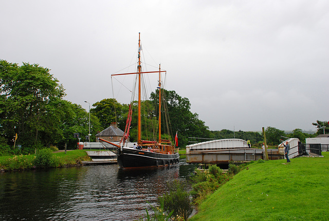
Caledonian Canal bei Inverness


Der Kaledonische Kanal (engl. Caledonian Canal) verbindet die Ost- und Westküste Schottlands.
Nur etwa ein Drittel des Kanals wurde künstlich geschaffen. Er verläuft, beginnend im Nordosten bei Inverness, durch folgende natürliche Gewässer: Moray Firth (Nordsee), River Ness, Loch Dochfour, Loch Ness, Loch Oich, Loch Lochy, Loch Linnhe und Firth of Lorne (Atlantischer Ozean).
Für den Bau des Kaledonischen Kanals war der berühmte schottische Ingenieur Thomas Telford verantwortlich. Der Kanal wurde von 1803 bis 1822 gebaut. Der Bau diente zur Zeit der Highland Clearances auch zur Schaffung neuer Arbeitsplätze.
Der Kanal erreichte nach seiner Fertigstellung nicht die wirtschaftliche Bedeutung, die ihm zuerst beigemessen wurde. Heute dient er hauptsächlich der Erholung und dem Tourismus. Er wird seit 1963 von British Waterways bewirtschaftet. 2007 wurde der Caledonian Canal von der American Society of Civil Engineers in die List of International Historic Civil Engineering Landmarks aufgenommen.
Um die Höhenunterschiede der einzelnen Lochs auszugleichen, bedarf es neunundzwanzig Schleusen. Die Gesamtlänge des Kanals beträgt 97 km.
The Caledonian Canal connects the Scottish east coast at Inverness with the west coast at Corpach near Fort William in Scotland. The canal was constructed in the early nineteenth century by Scottish engineer Thomas Telford, and is a sister canal of the Göta Canal in Sweden, also constructed by Telford.
The canal runs some 60 miles (97 km) from northeast to southwest. Only one third of the entire length is man-made, the rest being formed by Loch Dochfour, Loch Ness, Loch Oich, and Loch Lochy. These lochs are located in the Great Glen, on a geological fault in the Earth's crust. There are 29 locks (including eight at Neptune's Staircase, Banavie), four aqueducts and 10 bridges in the course of the canal. Q. Wikipedia
Translate into English
Nur etwa ein Drittel des Kanals wurde künstlich geschaffen. Er verläuft, beginnend im Nordosten bei Inverness, durch folgende natürliche Gewässer: Moray Firth (Nordsee), River Ness, Loch Dochfour, Loch Ness, Loch Oich, Loch Lochy, Loch Linnhe und Firth of Lorne (Atlantischer Ozean).
Für den Bau des Kaledonischen Kanals war der berühmte schottische Ingenieur Thomas Telford verantwortlich. Der Kanal wurde von 1803 bis 1822 gebaut. Der Bau diente zur Zeit der Highland Clearances auch zur Schaffung neuer Arbeitsplätze.
Der Kanal erreichte nach seiner Fertigstellung nicht die wirtschaftliche Bedeutung, die ihm zuerst beigemessen wurde. Heute dient er hauptsächlich der Erholung und dem Tourismus. Er wird seit 1963 von British Waterways bewirtschaftet. 2007 wurde der Caledonian Canal von der American Society of Civil Engineers in die List of International Historic Civil Engineering Landmarks aufgenommen.
Um die Höhenunterschiede der einzelnen Lochs auszugleichen, bedarf es neunundzwanzig Schleusen. Die Gesamtlänge des Kanals beträgt 97 km.
The Caledonian Canal connects the Scottish east coast at Inverness with the west coast at Corpach near Fort William in Scotland. The canal was constructed in the early nineteenth century by Scottish engineer Thomas Telford, and is a sister canal of the Göta Canal in Sweden, also constructed by Telford.
The canal runs some 60 miles (97 km) from northeast to southwest. Only one third of the entire length is man-made, the rest being formed by Loch Dochfour, Loch Ness, Loch Oich, and Loch Lochy. These lochs are located in the Great Glen, on a geological fault in the Earth's crust. There are 29 locks (including eight at Neptune's Staircase, Banavie), four aqueducts and 10 bridges in the course of the canal. Q. Wikipedia
, Erhard Bernstein, ©UdoSm, Ulrich John have particularly liked this photo
- Keyboard shortcuts:
Jump to top
RSS feed- Latest comments - Subscribe to the comment feeds of this photo
- ipernity © 2007-2024
- Help & Contact
|
Club news
|
About ipernity
|
History |
ipernity Club & Prices |
Guide of good conduct
Donate | Group guidelines | Privacy policy | Terms of use | Statutes | In memoria -
Facebook
Twitter

Erika+Manfred club has replied to Ulrich John clubErika+Manfred club has replied to ©UdoSm clubVG, erika
Sign-in to write a comment.