Sunset at Whitsundays Islands
Molde
Der Zaun bei den Kata Tjutas
Calvi, der Hafen und die Stadt
Sunset at Evans Head
Blaue Stunde am See
Der Heringszaun von Kappeln
Giardino Naxos, Sizilien, Italy
New Grange, Co. Sligo, Irland
Sunset at San Leone, Sizilien, Italien
Skyline, Frankfurt am Main
Greetings to the sun, Zadar, Croatia
Flying to the sun, Zadar, Croatia
Sunset at Lido di Jesolo, Venetien, Italy
Tag 49 - Sunrise at Narooma, NSW, Australia
Ayers Rock, NT, Australia
Sunset at Phillip Island, Victoria. Australia,
Pitlochry, River Tummel
English Bay, Vancouver
Johnson Street Bridge, Victoria
Canada Place
Luminale Frankfurt - Messeturm
Luminale Frankfurt - Hauptbahnhof
1/500 • f/4.5 • 40.0 mm • ISO 100 •
NIKON CORPORATION NIKON D5200
Location
See also...
Keywords
Authorizations, license
-
Visible by: Everyone -
All rights reserved
-
656 visits
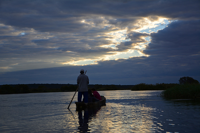
Sonnenuntergang am Sambesi River


Der Sambesi (auch Zambezi oder Zambesi) ist der viertlängste Fluss in Afrika und der größte afrikanische Strom, der in den Indischen Ozean fließt. Das Einzugsgebiet umfasst Gebiete in acht Staaten im südlichen Afrika und umfasst ca. 1,33 Millionen Quadratkilometer (km²), was etwa der Hälfte dessen des Nil entspricht. Damit handelt es sich um das viertgrößte Flusssystem in Afrika. Weltweit ist er vor allem durch die Victoriafälle bekannt.
Seine Quelle befindet sich im Zambezi Source National Forest und liegt auf der Lundaschwelle in Sambia, an der Grenze zwischen Demokratischer Republik Kongo und Angola. Er ist insgesamt 2574 Kilometer lang. Er fließt durch Angola, Sambia und Mosambik, wo er in einem 880 km² großen Delta in den Indischen Ozean mündet. Er bildet auch teilweise die Grenze von Sambia und Namibia, sowie Sambia und Simbabwe, wo er auf Höhe der Städte Livingstone (Sambia) und Victoria Falls (Simbabwe) den mächtigsten Wasserfall Afrikas, die Viktoriafälle, bildet und dort etwa 110 Meter in die Tiefe fällt. Weitere Wasserfälle sind die Chavumafälle an der Grenze zwischen Sambia und Angola und die Ngonyefälle, die sich nahe Sioma im Westen Sambias befinden. Der Sambesi wird über die gesamte Flusslänge von lediglich neun Brücken überspannt
Der Sambesi ist im Unterlauf ab Tete schiffbar. Im Sambesi kommen bis heute Flusspferde vor.
The Zambezi (also spelled Zambeze and Zambesi) is the fourth-longest river in Africa, the longest east flowing river in Africa and the largest flowing into the Indian Ocean from Africa. The area of its basin is 1,390,000 square kilometres (540,000 sq mi), slightly less than half that of the Nile. The 2,574-kilometre-long river (1,599 mi) rises in Zambia and flows through eastern Angola, along the eastern border of Namibia and the northern border of Botswana, then along the border between Zambia and Zimbabwe to Mozambique, where it crosses that country to empty into the Indian Ocean.
The Zambezi's most noted feature is Victoria Falls. Other notable falls include the Chavuma Falls at the border between Zambia and Angola, and Ngonye Falls, near Sioma in Western Zambia.
There are two main sources of hydroelectric power on the river, the Kariba Dam, which provides power to Zambia and Zimbabwe, and the Cahora Bassa Dam in Mozambique, which provides power to Mozambique and South Africa. There is also a smaller power station at Victoria Falls. Q: Wikipedia
ColRam, Antje P., Sami Serola (inactive), Buelipix and 9 other people have particularly liked this photo
- Keyboard shortcuts:
Jump to top
RSS feed- Latest comments - Subscribe to the comment feeds of this photo
- ipernity © 2007-2024
- Help & Contact
|
Club news
|
About ipernity
|
History |
ipernity Club & Prices |
Guide of good conduct
Donate | Group guidelines | Privacy policy | Terms of use | Statutes | In memoria -
Facebook
Twitter

Sign-in to write a comment.